Home
Services
About us
Blog
Contacts
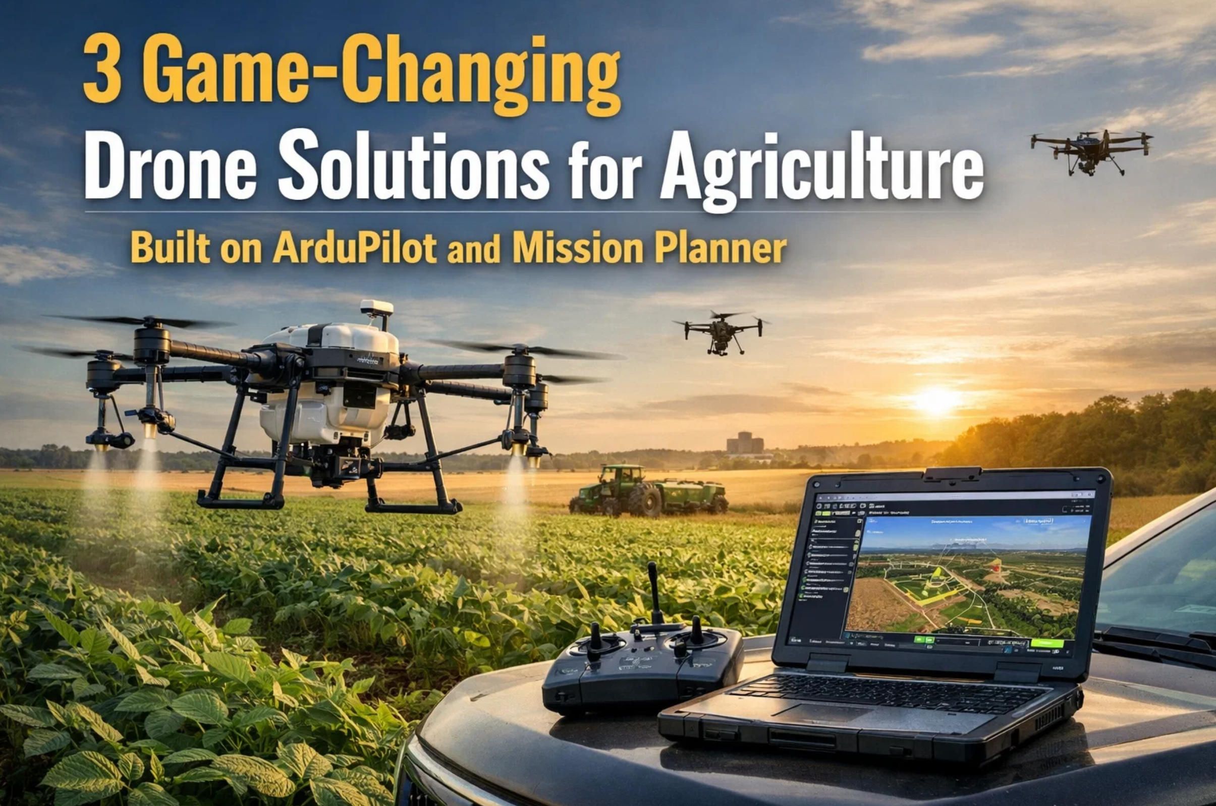
3 Game-Changing Drone Solutions for Agriculture Built on ArduPilot and Mission Planner
When a vineyard owner in Napa Valley loses 15 percent of a Cabernet Sauvignon harvest to undetected powdery mildew, the damage is not just agricultural — it is financial, reputational, and deeply personal. When a cattle rancher in Montana spends three days on horseback searching for a dozen strays hidden in brushy coulees, the cost is measured in labor hours, fuel, and animals that needed veterinary attention two days ago. When a wheat farmer in Kansas applies nitrogen uniformly across 2,000 acres despite knowing that soil variability makes some zones hungry and others already saturated, the waste shows up in both the input bill and the runoff report.
These are not hypothetical problems. They are daily realities across the global agricultural sector, an industry where drone technology is no longer a novelty but a competitive necessity. According to MarketsandMarkets, the agriculture drones market is projected to grow from USD 2.63 billion in 2025 to USD 10.76 billion by 2030, registering a CAGR of 32.6 percent. The growth is driven by precision farming, labor shortages, and the relentless pressure to produce more food with fewer resources and less environmental impact.
A-Bots.com, a full-cycle custom software development company with offices in the USA, Ukraine, and Romania, has positioned itself at the intersection of drone hardware and intelligent software. With a technology stack that spans React Native, Python/Django, Java, Kotlin, Swift, and Node.js — and a portfolio of more than 70 completed projects including IoT applications like the Shark Clean robotic vacuum controller — A-Bots.com brings the same engineering discipline to drone software that it applies to any complex embedded or mobile system. The company develops custom ArduPilot firmware extensions, Mission Planner plug-ins, companion computer pipelines, and cloud-based analytics dashboards that turn raw aerial data into decisions a farmer can act on before breakfast.
What sets A-Bots.com apart is not just coding skill but domain fluency. Building a drone solution for agriculture means understanding MAVLink telemetry packets, camera trigger timing at 3 frames per second, NDVI index thresholds that separate healthy chlorophyll from early-stage nitrogen deficiency, and the regulatory nuance of flying a 25-kilogram hexacopter beyond visual line of sight over a cattle operation in Wyoming. The company's QA and testing division validates every firmware module through hardware-in-the-loop (HITL) and software-in-the-loop (SITL) simulation before a single propeller spins in the field, ensuring that a client's investment is protected by the same rigor applied to mission-critical aerospace systems.
This article is the first in a three-part series exploring nine real-world drone use cases built on the ArduPilot and Mission Planner ecosystem. Each case identifies the industry problem, specifies the hardware and software architecture, details what needs to be custom-developed, and quantifies the expected return. In this installment, we focus on agriculture — arguably the largest addressable market for commercial drones worldwide.
Case 1: Multispectral Vineyard Health Monitoring and Early Disease Detection
The Problem
Grapevine diseases like downy mildew (Plasmopara viticola), powdery mildew (Erysiphe necator), and Esca complex do not announce themselves with visible symptoms until the pathogen has already colonized significant tissue. By the time a scout walking between rows spots yellowing leaves or oily lesions, the infection window for effective fungicide application has often closed. A 2024 study published in the MDPI journal Drones demonstrated that combining multispectral imaging with deep learning achieved 96 percent accuracy in detecting grapevine downy mildew — well before symptoms became visible to the human eye.
Vineyards present unique surveying challenges. Row spacing varies from 1.5 to 3 meters depending on trellis system. Canopy architecture changes dramatically between veraison and harvest. Terrain can be steep — Mosel Valley slopes exceed 60 percent grade, and even Willamette Valley blocks often sit on 15-to-20-degree hillsides. A fixed survey altitude produces inconsistent ground sample distance (GSD) when terrain undulates, and conventional grid missions designed for flat broadacre fields miss the inter-row detail that viticulturists need.
Hardware Architecture
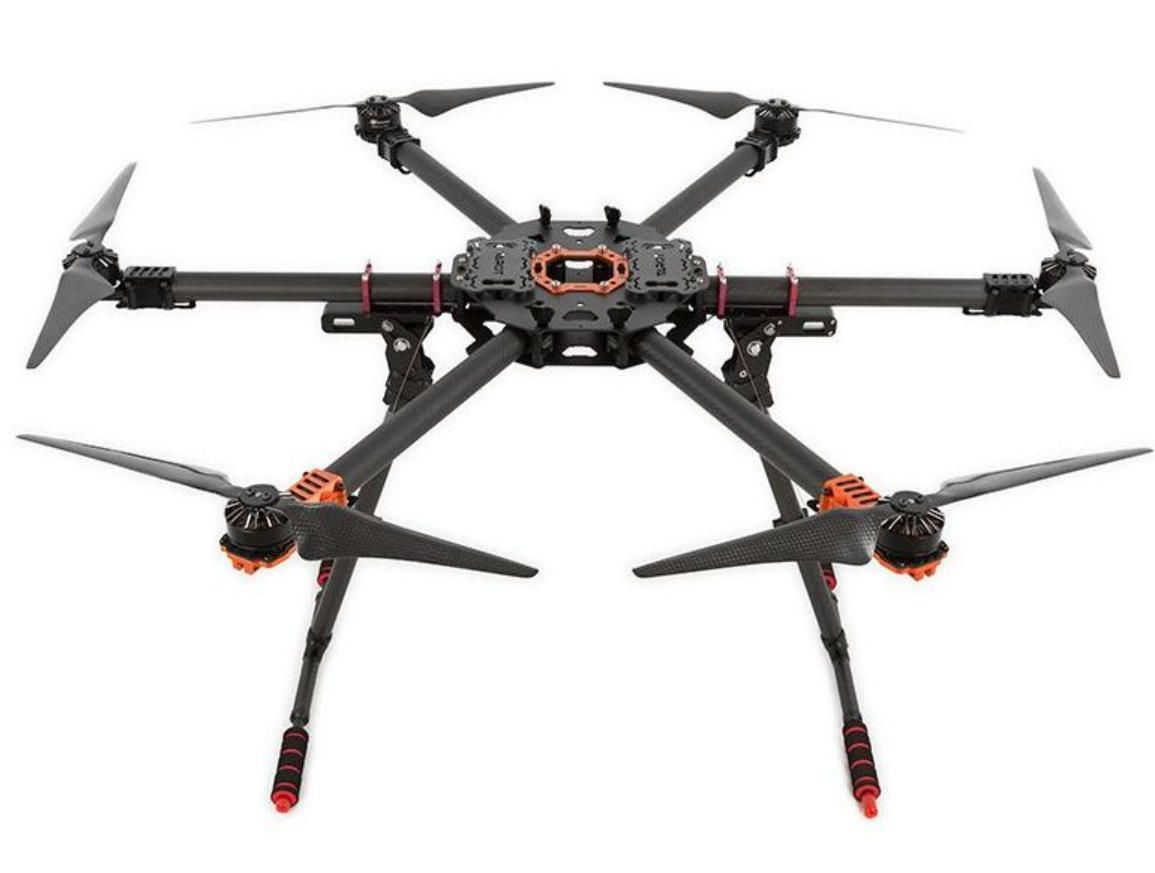
The optimal platform for vineyard mapping is a hexacopter built on a frame like the EFT E616 or Tarot T960, powered by a Cube Orange+ or Holybro Pixhawk 6X flight controller running ArduCopter 4.5 or later. The hexacopter configuration provides redundancy — losing one motor does not mean losing the aircraft and, more importantly, the sensor payload worth several thousand dollars.
The sensor of choice is the MicaSense RedEdge-P, a six-band multispectral camera that simultaneously captures blue (475 nm), green (531 nm), red (650 nm), red edge (705 nm), near-infrared (842 nm), and a 5.1-megapixel panchromatic band. The panchromatic band enables pansharpened output at 2 cm GSD from 60 meters altitude — twice the resolution of the previous-generation RedEdge-MX. The RedEdge-P communicates natively with Pixhawk-class flight controllers via MAVLink v1.0 serial protocol at 57,600 baud, accepting DO_SET_CAM_TRIGG_DIST commands that synchronize image capture with the aircraft's ground track.
The Downwelling Light Sensor (DLS 2), included in the RedEdge-P kit, mounts on a mast atop the airframe with an unobstructed sky view. It records ambient irradiance and sun angle for each of the camera's spectral bands, writing calibration data directly into each TIFF image's metadata. This allows processing software — Pix4Dfields, Agisoft Metashape, or OpenDroneMap — to correct for cloud shadows mid-flight, a frequent issue in maritime-influenced wine regions.
A downward-facing LiDAR rangefinder such as the LightWare SF11/C (range 0.2 to 120 m, update rate 20 Hz) enables ArduPilot's surface tracking mode, configured through the SURFTRAK_MODE parameter. This keeps the aircraft at a constant above-ground-level (AGL) altitude as it traverses sloped vineyard blocks, maintaining consistent GSD across every image. For terrain beyond the rangefinder's operational ceiling, ArduPilot's terrain-following engine ingests SRTM elevation tiles (100 m grid spacing from the ArduPilot server, or 30 m SRTM1 data loaded via MAVProxy) cached on the autopilot's SD card.
Mission Planning in Detail
In Mission Planner, the operator draws a polygon around the vineyard block using the Draw Polygon tool, then selects Auto WP → Survey (Grid). The camera configuration dialog accepts the RedEdge-P's sensor dimensions (4.8 mm × 3.6 mm sensor for each multispectral band), focal length (5.5 mm), and image resolution (1280 × 960 per band). Setting front overlap to 80 percent and side overlap to 70 percent — the minimum recommended for reliable photogrammetric stitching in canopy environments — Mission Planner auto-calculates DO_SET_CAM_TRIGG_DIST, the distance in meters between consecutive shutter triggers.
For a vineyard block on a 15-degree slope, the mission altitude should be set using terrain-relative waypoints. In Mission Planner's waypoint editor, switching the altitude reference from "Relative" to "Terrain" instructs ArduPilot to maintain the specified AGL using SRTM data or the onboard rangefinder. The TERRAIN_ENABLE parameter must be set to 1, and TERRAIN_SPACING to 100 (matching the SRTM server resolution). If flying below 60 meters AGL — common in vineyard work to achieve sub-centimeter GSD — the LiDAR rangefinder provides the necessary accuracy that SRTM alone cannot guarantee, given its typical 10-to-20-meter vertical error.
Turnaround distance should be set to at least 15 meters beyond the polygon boundary to allow the hexacopter to decelerate, reverse, and stabilize before re-entering the survey corridor. The "Hover and Capture" option should be enabled for multirotor platforms in vineyard missions; this causes the aircraft to pause momentarily at each trigger point, eliminating motion blur in multispectral imagery and ensuring all six bands capture the same scene without temporal offset.
What A-Bots.com Custom-Develops
Out-of-the-box Mission Planner and ArduPilot handle waypoint generation and camera triggering, but vineyard-grade solutions require significant custom software:
Vine-Row-Aware Flight Path Generator. Standard grid surveys fly parallel strips regardless of row orientation. A-Bots.com develops a Mission Planner plug-in that imports vine row shapefiles (from GIS surveys or prior RGB orthomosaics) and generates flight paths aligned to the inter-row corridors. This eliminates oblique viewing angles that cause canopy shadowing and ensures each row receives consistent nadir coverage. The plug-in outputs standard MAVLink waypoint files compatible with any ArduPilot vehicle.
Real-Time NDVI Anomaly Alerting. Rather than waiting for post-flight processing, A-Bots.com builds a companion computer pipeline (running on a Raspberry Pi 4 or NVIDIA Jetson Nano mounted on the airframe) that ingests the RedEdge-P's Ethernet API feed, computes NDVI on-the-fly using the formula (NIR − Red) / (NIR + Red), and flags tiles where the index drops below a configurable threshold (typically 0.3 for severe stress, 0.5 for early warning). Alerts are relayed to the ground station via MAVLink telemetry as custom status messages, allowing the pilot to mark zones of interest for immediate ground scouting.
Cloud Dashboard with Time-Series Analysis. Vineyard health is a longitudinal story. A-Bots.com builds a Django-based web platform where processed orthomosaics, NDVI maps, and NDRE (Normalized Difference Red Edge) maps are uploaded after each flight. The dashboard overlays flights chronologically, highlighting zones where vegetation indices have declined between successive surveys. Agronomists can set per-block alert thresholds, receive email or Telegram notifications, and generate spray prescription maps exportable to variable-rate application equipment.
ArduPilot Lua Script for Adaptive Altitude. For vineyards with extreme slope variation within a single block, A-Bots.com writes Lua scripting extensions (supported in ArduPilot 4.1+) that dynamically adjust the target AGL based on the real-time rangefinder reading, overriding the planned altitude when terrain diverges from the SRTM model by more than 5 meters. This prevents GSD inconsistency that would compromise NDVI comparability across the block.
Measurable Outcomes
Research across vineyard operations using multispectral drone surveys reports fungicide savings of 25 to 40 percent through targeted rather than blanket application, early disease detection 7 to 14 days before visual symptoms, and yield preservation of 10 to 20 percent in blocks where drone data triggered timely intervention. For a 50-hectare estate producing wine at USD 15,000 per hectare, a 15-percent yield save on even a single badly affected block represents USD 112,500 in preserved revenue — many times the cost of the drone system and annual software license.
Case 2: Variable-Rate Prescription Mapping for Broadacre Crops
The Problem
Uniform application of fertilizer across a 2,000-acre wheat or corn field is an expensive fiction. Soil organic matter, moisture-holding capacity, pH, and residual nitrogen vary dramatically within a single quarter-section. A strip of sandy loam along a creek bed metabolizes nitrogen at a different rate than the clay knoll 400 meters away. Yet most conventional operations still apply a flat rate of 150 to 180 pounds of nitrogen per acre across the entire field because they lack the data granularity to do otherwise.
The economic penalty is twofold. In over-applied zones, excess nitrogen leaches into groundwater or volatilizes as nitrous oxide — a greenhouse gas 273 times more potent than CO2 over a 20-year horizon. In under-applied zones, the crop starves and yields drop. Research published in precision agriculture journals consistently shows that variable-rate application (VRA) based on drone-derived prescription maps reduces nitrogen input by 15 to 25 percent while maintaining or increasing yield, and farms using drones for precision agriculture report 20 to 30 percent productivity gains.
Hardware Architecture
Broadacre crop mapping favors fixed-wing or VTOL platforms for their superior endurance and coverage rates. A VTOL airframe like the Wingcopter 198 or the open-source MakeFlyEasy Freeman 2300 — both compatible with ArduPilot's QuadPlane firmware — can cover 200 to 400 hectares per flight on a single battery, compared to 20 to 40 hectares for a typical quadcopter.
The flight controller is again the Cube Orange+ or Holybro Pixhawk 6X, running ArduPlane firmware with QuadPlane VTOL support enabled. The Q_ENABLE parameter is set to 1, and transition parameters (Q_TRANSITION_MS, ARSPD_FBW_MIN) are tuned to the specific airframe's stall speed and motor configuration.
For broadacre VRA mapping, the MicaSense RedEdge-P remains the gold standard, but operators on a tighter budget can use the RedEdge-MX (five bands: blue, green, red, red edge, NIR) which still delivers reliable NDVI and NDRE indices at 8 cm GSD from 120 meters AGL. The sensor integrates with ArduPilot via the same MAVLink serial interface at 57,600 baud, triggered by DO_SET_CAM_TRIGG_DIST commands calculated by Mission Planner's Survey Grid tool.
For fields where thermal stress mapping is also required (identifying irrigation inefficiency or waterlogged areas), adding a FLIR Vue Pro R 640 thermal camera provides calibrated radiometric thermal data at 640 × 512 resolution. The FLIR sensor can be triggered independently via a PWM signal from the Pixhawk's auxiliary output, synchronized to the same waypoint triggers.
RTK GPS is critical for VRA because the prescription map must align precisely with the variable-rate applicator's guidance system. The Here3+ RTK GPS module (CubePilot ecosystem) or Holybro H-RTK F9P provides centimeter-level horizontal accuracy when paired with a base station or NTRIP correction service. ArduPilot's EKF3 fuses RTK position, IMU data, and barometer readings to produce georeferenced trigger points accurate to within 2 centimeters.
Mission Planning in Detail
For a 2,000-acre field, the operator breaks the area into Mission Planner survey polygons sized to match the aircraft's endurance. A VTOL with 90 minutes of flight time at 18 m/s cruise speed and 120 m AGL covers approximately 300 hectares per sortie with 75/65 percent front/side overlap. The operator plans 7 missions, each with auto-takeoff (VTOL), transition to fixed-wing cruise, survey grid, transition back to VTOL hover, and auto-land at a pre-designated landing point.
Mission Planner's terrain-following is engaged for fields with topographic relief. The TERRAIN_ENABLE parameter is set to 1, and the mission waypoints use terrain-relative altitude frames. For fixed-wing aircraft, ArduPlane adjusts pitch and throttle to maintain the target AGL as terrain changes, using SRTM data cached on the SD card. The TERRAIN_LOOKAHEAD parameter (default 2000 meters) determines how far ahead the autopilot reads terrain, allowing smooth altitude transitions rather than abrupt climbs.
The camera trigger distance for a RedEdge-MX at 120 m AGL with 75 percent forward overlap is approximately 28 meters (calculated from GSD × image height × (1 − overlap)). Mission Planner computes this automatically when the camera profile is entered, but the operator should verify the calculation because field of view orientation (landscape vs. portrait) affects the result.
What A-Bots.com Custom-Develops
Multi-Mission Stitching and Batch Processing Pipeline. Seven separate flight missions generate thousands of individual TIFF images across five or six spectral bands. A-Bots.com builds an automated pipeline — typically a Python service running on a local workstation or cloud VM — that ingests raw imagery folders, validates geotag accuracy against RTK logs, performs radiometric calibration using DLS 2 metadata, and feeds the entire dataset into an OpenDroneMap or Pix4Dengine processing cluster. The output is a single seamless orthomosaic and a suite of vegetation index rasters covering the full 2,000 acres.
Prescription Map Generator. The processed NDVI and NDRE rasters are consumed by a custom Django application that segments the field into management zones using k-means clustering or user-defined thresholds. Each zone receives a nitrogen rate recommendation based on the agronomist's calibration curve (relating index values to yield potential). The output is an ISOXML or shapefile prescription map compatible with major VRA equipment brands — John Deere Operations Center, AGCO Fuse, CNH PLM, Raven Viper 4 — ensuring that the drone data flows directly into the tractor's rate controller without manual transcription.
Seasonal Comparison Engine. A single flight snapshot is useful, but the real power emerges when the same field is surveyed biweekly throughout the growing season. A-Bots.com's platform registers each orthomosaic to a common coordinate system using RTK ground control points, computes pixel-level change detection between dates, and generates trend maps that show whether a management zone is responding to treatment or continuing to decline. This time-series analysis transforms the drone from a scouting tool into a decision engine.
ArduPilot Battery-Swap Waypoint Resumption Module. A-Bots.com develops a firmware extension that saves the current mission index and vehicle state to non-volatile memory when the pilot initiates a return-to-launch for battery swap. After replacing the battery pack and re-arming, the aircraft resumes the mission from the exact waypoint where it left off, including the correct camera trigger distance state. This eliminates the gap-and-overlap errors that occur when operators manually restart a mission from an approximate point after a battery change.
Measurable Outcomes
A 2,000-acre corn operation applying a drone-derived VRA nitrogen prescription typically saves USD 15 to 25 per acre in reduced fertilizer input — a total savings of USD 30,000 to USD 50,000 per season. Simultaneously, yield in previously under-applied zones increases by 5 to 12 bushels per acre. At USD 4.50 per bushel, even a conservative 5 bushels per acre increase across half the field adds USD 22,500 in revenue. The combined benefit of input savings and yield gain often exceeds USD 50,000 annually — a return that pays for the drone platform, sensors, and A-Bots.com's custom software within the first season.
Case 3: Autonomous Livestock Monitoring, Headcount Verification, and Pasture Assessment
The Problem
The United States alone loses more than 2.5 million cattle annually to health problems, costing ranchers approximately USD 1.5 billion according to BBC Future reporting. Over 60 percent of those losses are health-related — conditions like bovine respiratory disease, foot rot, or calving complications that could have been treated if detected earlier. On a 1,000-head operation spread across 10,000 acres of rangeland, manual headcounts consume 8 to 12 hours of labor per week and still miss animals hidden in brush, ravines, or timber. A single missing cow-calf pair worth USD 2,500 can justify the cost of a drone system if found before it succumbs to exposure, predation, or illness.
Beyond headcount, pasture condition assessment drives stocking rate decisions that determine profitability for the entire season. Overgrazing degrades forage quality, triggers erosion, and invites invasive species. Undergrazing wastes carrying capacity. Traditionally, ranchers estimate pasture condition by windshield surveys — driving the perimeter and making visual judgments about grass height, bare ground percentage, and water availability. The result is a subjective, low-resolution picture that misses within-paddock variability.
Hardware Architecture
Livestock operations require two complementary platforms:
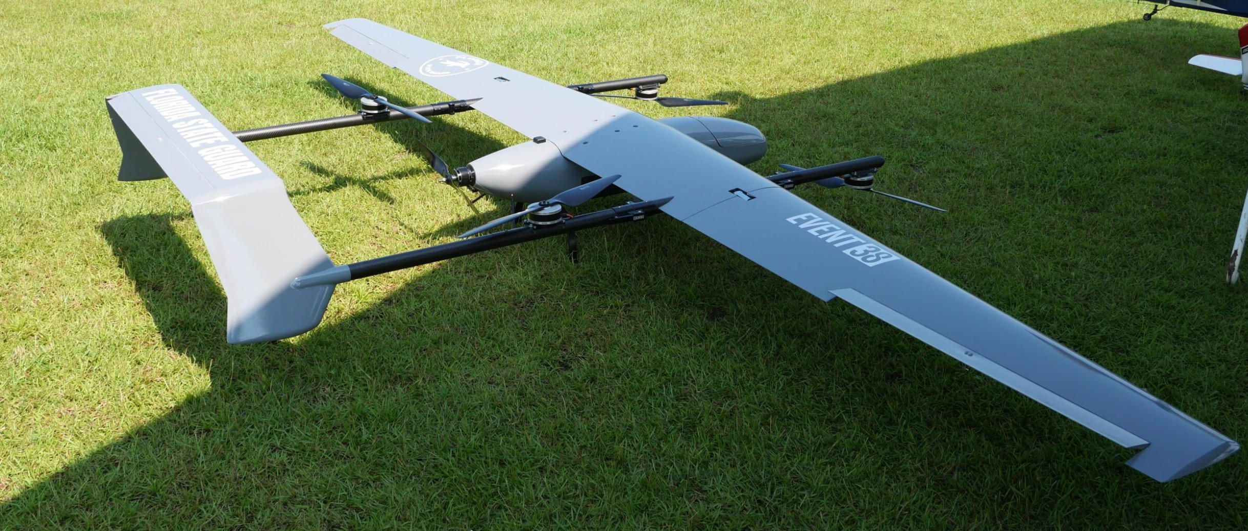
Long-Range Survey Platform. A fixed-wing drone like the Event 38 E400 or the MakeFlyEasy Striver Mini — both running ArduPlane firmware on a Pixhawk 6C or Cube Orange — covers 500 to 1,500 acres per flight at 60 to 80 meters AGL. This platform carries an RGB camera (Sony RX1R II or similar, 42 MP full-frame) for pasture NDVI assessment and an optional thermal camera (FLIR Boson 640 or DJI Zenmuse XT-S equivalent) for broad-area livestock detection. The fixed-wing platform excels at the weekly pasture-wide survey where coverage matters more than hovering precision.
Close-Inspection Multirotor. When the fixed-wing survey flags a zone of interest — a cluster of thermal signatures that does not match the expected headcount, or a section of pasture showing severe NDVI decline — a multirotor (quadcopter or hexacopter on an S500 or X500 V2 frame with Pixhawk 6C) is deployed for close inspection. Equipped with a 30x optical zoom camera or a thermal sensor, the multirotor hovers at 30 to 50 meters to identify individual animals, assess body condition score, and check for visible signs of distress without physically disturbing the herd.
For both platforms, a long-range telemetry link is essential. The RFD900x telemetry radio provides 40+ km range with MAVLink support, enabling BVLOS operations where regulations permit (FAA Part 107 waiver required in the US). ArduPilot's GCS failsafe (FS_GCS_ENABLE) is configured to trigger Return-to-Launch if telemetry is lost for more than 5 seconds, ensuring the aircraft recovers even if the radio link drops in a mountain valley.
Mission Planning in Detail
The ranch manager defines paddock boundaries in Mission Planner as separate survey polygons, each tagged with a paddock identifier. Weekly survey missions are saved as template files (.waypoint format) that can be reloaded and executed with a single click. The terrain-following mode uses SRTM data for the fixed-wing platform flying above 60 meters AGL, where the 10-to-20-meter vertical accuracy of the database is acceptable.
For thermal livestock detection, flight altitude is a critical trade-off. Flying too high (above 100 m AGL) causes individual animals to occupy fewer than 10 pixels in a 640 × 512 thermal image, making reliable detection difficult. Flying too low (below 40 m AGL) reduces coverage per sortie and increases flight time. The sweet spot for cattle detection with a FLIR Boson 640 (9 mm lens, 50-degree HFOV) is 60 to 80 meters AGL, yielding approximately 5 to 8 pixels per animal — sufficient for a YOLO-class detection model trained on thermal cattle imagery to achieve 95+ percent recall.
The Mission Planner survey grid for thermal flights uses wider strip spacing than multispectral surveys because detection does not require high overlap. A 30 percent side overlap is sufficient for headcount purposes, dramatically increasing the area covered per flight. The camera is triggered at fixed distance intervals using DO_SET_CAM_TRIGG_DIST, and the images are geotagged using the onboard GPS for later mapping.
What A-Bots.com Custom-Develops
Onboard AI Cattle Detection Module. A-Bots.com trains a YOLOv8 or YOLOv10 object detection model on a dataset of thermal and RGB cattle images captured across diverse rangeland environments — open grassland, brush cover, timber edges, feedlots, and water points. The trained model runs on an NVIDIA Jetson Orin Nano companion computer mounted on the fixed-wing airframe, processing each image as it is captured. Detected animals are counted and their GPS coordinates logged in real time. The count is transmitted to the ground station via a custom MAVLink message, giving the rancher a live headcount as the aircraft flies.
Paddock-Level Headcount Dashboard. The companion computer aggregates detections per paddock polygon, de-duplicates animals that appear in overlapping frames (using spatial clustering with a configurable radius, typically 3 meters), and generates a per-paddock headcount report. A-Bots.com's React-based web dashboard displays each paddock on a map with the current count, color-coded against the expected stocking rate. Discrepancies trigger alerts — if Paddock 7 should hold 120 head but only 108 are detected, the rancher knows to investigate.
Pasture Condition Index Calculator. Using RGB imagery from the fixed-wing survey, A-Bots.com's processing pipeline generates an NDVI raster (computed from the red and near-infrared channels if a modified camera or filter is used, or from visible-band vegetation indices like VARI or ExG for standard RGB cameras). The pipeline segments each paddock into condition zones: healthy (index > 0.6), moderate (0.35–0.6), degraded (< 0.35), and bare ground. A Python-based reporting module calculates available forage dry matter per hectare using empirical regression models calibrated to the ranch's specific grass species, outputting a grazing-days-remaining estimate for each paddock.
Automated Flight Scheduling via Cron Integration. For ranches that fly the same survey routes weekly, A-Bots.com develops an automation layer that generates Mission Planner waypoint files from paddock boundary shapefiles, uploads them to the autopilot via MAVProxy scripting, and triggers auto-takeoff at a scheduled time. The operator's role reduces to placing the aircraft on the launch point, confirming the pre-flight checklist, and pressing "Arm." Post-flight, the pipeline automatically ingests images from the SD card, runs detection and processing, and publishes the updated dashboard — no GIS expertise required.
Stray Animal Geofence Alert. ArduPilot's geofence system is normally used to constrain the drone itself, but A-Bots.com repurposes the concept for livestock. If the onboard AI detects cattle at GPS coordinates outside any defined paddock polygon, the system flags it as a potential stray or fence breach. The alert includes the animal's thermal thumbnail, GPS coordinates, and the nearest paddock boundary, enabling rapid response.
Measurable Outcomes
Drone-based livestock monitoring on a 10,000-acre ranch with 1,000 head typically reduces weekly labor for headcounts from 10+ hours to under 2 hours (including drone deployment, flight, and result review). At USD 25 per hour for ranch labor, that saves approximately USD 10,000 per year in direct labor costs. Early detection of a single sick animal that would otherwise have been lost saves USD 1,500 to USD 3,000 in animal value. Finding two or three strays per season that manual searches missed adds another USD 5,000 to USD 7,500 in recovered value. Improved pasture rotation guided by drone NDVI data can increase carrying capacity by 10 to 15 percent without degrading forage quality, translating to additional revenue from higher stocking rates or reduced supplemental feed costs.
The Technical Common Ground: Why ArduPilot and Mission Planner
All three use cases share a common software foundation — and that commonality is a strategic advantage, not a coincidence.
ArduPilot is open-source firmware that runs on more than 30 flight controller boards, from the USD 50 Holybro Pixhawk 6C Mini to the USD 500 CubePilot Cube Orange+. It supports multirotor, fixed-wing, VTOL, rover, and submarine vehicle types with a single codebase. This means a farm that starts with a quadcopter for vineyard mapping can later add a fixed-wing for broadacre surveys and a ground rover for soil sampling — all managed through the same Mission Planner ground station, the same MAVLink protocol, and the same parameter framework.
Mission Planner, created by Michael Oborne, is a full-featured Windows-based ground control station that handles firmware loading, vehicle configuration, mission planning, real-time telemetry monitoring, and post-flight log analysis. Its Survey Grid tool auto-generates camera-control waypoints for any arbitrary polygon, calculating trigger distances from sensor specifications. Its terrain data engine downloads SRTM tiles and caches them on the autopilot's SD card for terrain-following flights. Its tuning interface exposes every ArduPilot parameter with contextual tooltips, making it accessible to operators who are drone-literate but not embedded-systems engineers.
The critical advantage for agricultural enterprises is that ArduPilot and Mission Planner are vendor-neutral. The farmer is not locked into a single hardware manufacturer's ecosystem. If a Pixhawk 6X goes out of production, the firmware runs on a Cube Orange+. If the MicaSense RedEdge-P is unavailable, the camera trigger interface works with any sensor that accepts MAVLink, PWM, or GPIO signals. This flexibility protects the client's investment and ensures that the custom software A-Bots.com develops on top of the ecosystem retains its value regardless of hardware evolution.
What Comes Next
This is part one of a three-part series. In the next article, we will explore three use cases in the energy and infrastructure sector — solar farm inspection, power line corridor monitoring, and pipeline surveillance — where ArduPilot-based drones equipped with thermal sensors and LiDAR payloads are replacing helicopter patrols and manual climbing crews. In part three, we will cover construction site progress monitoring, mining volumetric surveys, and search-and-rescue operations.
Each case follows the same principle: identify a real operational pain point, architect a drone solution on the proven ArduPilot and Mission Planner foundation, and layer custom software from A-Bots.com to bridge the gap between raw aerial data and actionable business intelligence.
If your agricultural operation is ready to move beyond manual scouting and uniform application — if you need a drone solution that integrates with your existing equipment, speaks your agronomist's language, and delivers ROI in the first season — A-Bots.com is ready to build it. The company's engineers work with your team to define requirements, configure hardware, develop custom firmware and software, run SITL and HITL testing, and support field deployment. Contact A-Bots.com at info@a-bots.com or through Telegram at @Alphabots_support to start the conversation.
Here is the list of ArduPilot-compatible drone models applicable to the three agricultural cases:
Case 1 — Vineyard Multispectral Monitoring (Multirotor Platforms)
These missions require low-altitude precision, hover-and-capture capability, and stable flight on sloped terrain. Hexacopter configurations are preferred for motor redundancy when carrying expensive multispectral sensors.
- Holybro X500 V2 — carbon fiber quadcopter development kit, Pixhawk 6C/6X compatible, ~18 min flight time, payload mount for companion computer (Raspberry Pi 4 / Jetson Nano). Suitable for small vineyard blocks up to 10–15 hectares per flight. Starting price ~USD 500 (frame kit).
- Holybro X650 — larger frame with foldable aluminum arm connectors, 20 mm carbon fiber tube arms, compatible with Pixhawk 6C/6X. Supports heavier payloads (MicaSense RedEdge-P + DLS 2 + LiDAR rangefinder). Improved endurance over X500 due to larger propellers.
- EFT E610 / E616 — agricultural hexacopter frame, max takeoff weight up to 16–25 kg, widely used in precision agriculture builds with Pixhawk Cube autopilots. Provides the motor redundancy critical for vineyard overflights. Payload capacity allows simultaneous multispectral camera and companion computer.
- Tarot T960 — foldable hexacopter frame, 960 mm wheelbase, carbon fiber arms, supports up to 2–3 kg payload with 25–30 min flight time on 6S batteries. Popular among ArduPilot integrators for custom mapping builds.
- Tarot T810 — hexacopter, 810 mm wheelbase, lighter and more compact than T960. Good for vineyard blocks with tight headland access where a smaller footprint matters.
- Freefly Astro — commercial-grade quadcopter, Pixhawk-based with RTK, 61 MP Sony camera option, LTE cloud connectivity. ~40 min flight time. Pre-integrated with ArduPilot-compatible mission computer. Higher price point (~USD 15,000+) but turnkey for operators who need immediate deployment.
Case 2 — Broadacre Variable-Rate Prescription Mapping (Fixed-Wing and VTOL Platforms)
These missions prioritize endurance and coverage area. A VTOL platform eliminates the need for runways or catapult launchers while maintaining fixed-wing cruise efficiency.
- Event 38 E400 — carbon fiber fixed-wing VTOL, 90 min flight time, 3 lb (1.36 kg) payload capacity, ArduPlane QuadPlane firmware. NDAA-compliant, made in USA. Swappable payload bay (photogrammetry, multispectral, thermal, LiDAR). Starting price ~USD 18,900. Covers 200–400 hectares per sortie at 120 m AGL.
- Event 38 E455 — heavy-lift VTOL variant, larger payload capacity for dual-sensor configurations (e.g., RedEdge-P + FLIR thermal simultaneously). Extended endurance up to 2.5 hours in ISR configuration.
- MakeFlyEasy Freeman 2300 — EPO fixed-wing VTOL, 2300 mm wingspan, ArduPlane compatible, ~90 min flight time with 600 g payload. Affordable entry point for broadacre mapping. Available as PNP (plug-and-play) kit requiring separate Pixhawk flight controller, GPS, and radio. Price ~USD 1,500–2,000 (PNP frame).
- MakeFlyEasy Freeman 2100 — slightly smaller variant, 2100 mm wingspan, similar endurance profile. Good for operators who need a more portable airframe for truck-bed transport.
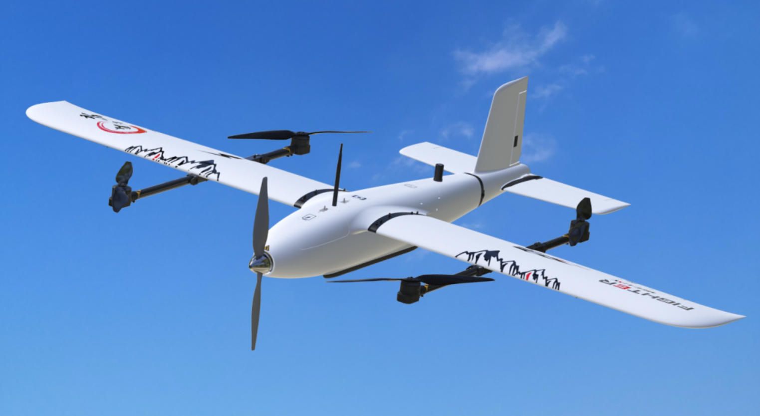
- MakeFlyEasy Fighter VTOL — 2430 mm wingspan, max takeoff weight 11.5 kg, payload up to 1.5 kg, 120–134 min flight time at 19 m/s cruise. Practical ceiling 4000 m. Carbon fiber / EPO construction. Tool-less disassembly for field transport. One of the best range-to-price ratios for agricultural survey.
- MakeFlyEasy Hero 2180 — 2180 mm wingspan VTOL, ~136 min endurance at 19 m/s with 600 g payload. Operational altitude up to 5000 m, wind resistance Class 5. Compact transport box (1250 mm).
- MakeFlyEasy Striver Mini VTOL — smallest in the MakeFlyEasy VTOL lineup. Hand-portable, quick deployment for smaller fields (200–500 acres). Shorter endurance (~60 min) but extremely convenient for rapid multi-field surveys.
- Raefly VT240 Pro — VTOL fixed-wing, ArduPilot-compatible, designed for commercial mapping and survey operations. Payload flexibility for multispectral and RGB cameras.
- Raefly VT290 — larger platform with extended endurance and heavier payload support for dual-camera setups.
- ARACE ROC QuadPlane — VTOL quadplane, ArduPilot-supported, suitable for commercial survey operations.
- Holybro Swan-K1 — ArduPilot-native VTOL, integrated Pixhawk flight controller, designed for mapping and survey with minimal assembly required.
- MotoDoro Farm Mapper — purpose-built fixed-wing for agricultural mapping, ArduPlane firmware, hand-launch capable. Budget option for operators who do not need VTOL functionality.
Case 3 — Livestock Monitoring and Pasture Assessment (Dual-Platform: Fixed-Wing + Multirotor)
This use case requires two complementary platforms: a fixed-wing for broad pasture surveys and a multirotor for close animal inspection.
Fixed-Wing (Pasture Survey):
- Event 38 E400 — same platform as Case 2, configured with thermal payload (FLIR Boson 640 or NextVision EO/IR gimbal) for cattle detection across 500–1,500 acres per flight.
- MakeFlyEasy Fighter VTOL — with thermal camera integration, suitable for broad rangeland sweeps at 60–80 m AGL. Long endurance ideal for large ranches.
- MakeFlyEasy Striver Mini (hand-launch version) — for ranches without VTOL requirements, quick deployment, 60+ min endurance for paddock-level surveys.
- TuffWing UAV Mapper — rugged foam fixed-wing, ArduPlane compatible, hand-launched, designed for field conditions. Budget-friendly option for smaller cattle operations.
- DRONEE Mapping Plane — simple ArduPlane-based fixed-wing for easy-to-use mapping missions. Low-cost entry for ranchers new to drone surveying.
Multirotor (Close Inspection):
- Holybro S500 V2 — compact quadcopter kit, Pixhawk 6C compatible, suitable for mounting a 30x zoom or thermal camera for individual animal inspection at 30–50 m AGL. Budget-friendly (~USD 300 frame kit).
- Holybro X500 V2 — slightly larger, better payload capacity for Jetson Nano companion computer running onboard AI detection models.
- EFT E410S — lightweight quadcopter frame designed for inspection tasks. Mounts thermal or zoom cameras for close-up livestock assessment.
Flight Controllers Compatible Across All Cases
- CubePilot Cube Orange+ — triple-redundant IMU, STM32H757, vibration-isolated, premium choice for commercial operations
- Holybro Pixhawk 6X — FMUv6 standard, STM32H753, dual IMU, designed for professional use
- Holybro Pixhawk 6C — STM32H743, cost-effective option, suitable for development and lighter commercial deployments
- Holybro Pixhawk 6C Mini — compact form factor for smaller frames (S500, Striver Mini)
- CUAV Pixhawk V6X — industrial design variant, cube or flat form factor, STM32H7
- Matek H743-WING V3 — lightweight controller for fixed-wing builds where size and weight are critical
All models above run ArduPilot firmware (ArduCopter, ArduPlane, or QuadPlane) and integrate with Mission Planner for survey grid planning, terrain following, and camera trigger control via MAVLink.
✅ Hashtags
#ArduPilotAgriculture
#MissionPlannerDrones
#PrecisionFarmingDrones
#DroneVineyardMonitoring
#NDVICropMapping
#LivestockDroneMonitoring
#CustomDroneSoftware
Other articles
Dyson WashG1 vs Tineco Floor One S7 Pro Dyson WashG1 and Tineco Floor One S7 Pro may target the same category, but they reflect two different product strategies. This article compares their cleaning hardware, usability, maintenance logic, and mobile app experience to show how premium wet floor cleaners are evolving. Beyond the buying decision, it also explores a bigger market trend: why companion software is becoming a serious competitive advantage in smart home appliances. For brands entering this segment, the comparison highlights what today’s floor washers do well - and what a custom app developed by A-Bots.com could do better.
App Controlled Scent Diffuser: Top 3 Reviewed Pura, AromaTech, Aera The app controlled scent diffuser market is booming, with the global aromatherapy diffuser industry valued at $1.72 billion in 2025 and growing at over 7% annually. This expert review compares the three leading smart fragrance systems — Pura, AromaTech, and Aera — analyzing their companion apps, connectivity approaches, and real user feedback. The article breaks down essential features every app controlled scent diffuser needs, from scheduling and intensity control to smart home integration and OTA firmware updates. Manufacturers looking to build or improve their own connected diffuser product will find a clear roadmap for custom IoT app development with A-Bots.com.
App Controlled Outlet: Tapo P210M vs Eve Energy Outlet The app controlled outlet market is entering a new phase as in-wall smart outlets replace traditional receptacles in American homes. This article delivers a detailed head-to-head comparison of the two leading in-wall app controlled outlet products available in the United States — the TP-Link Tapo P210M and the Eve Energy Outlet. Evaluated through the lens of their companion mobile applications, the comparison covers energy monitoring, scheduling, privacy architecture, Matter integration, and setup experience. Market data from Consegic Business Intelligence and Mordor Intelligence frames the growth opportunity, while A-Bots.com demonstrates how expert IoT app development powers the next generation of connected home devices.
DJI Agras T100 vs Hylio AG-272: Best Heavy-Duty Ag Drones Agricultural drones have evolved from lightweight scouting tools into heavy-duty industrial platforms capable of spraying thousands of acres per week. This in-depth comparison examines two leading heavy-duty models — the DJI Agras T100 with its 100-liter spray tank and advanced LiDAR sensing, and the Hylio AG-272, a Texas-built workhorse offering fleet coordination of up to three drones from a single operator station. The article covers specifications, obstacle avoidance systems, regulatory considerations including NDAA compliance, alternative drone applications beyond spraying, and the critical role of custom software in maximizing drone ROI for modern farming operations.
DJI Agras T25P vs XAG V40: Best Drones for Vineyards Vineyards demand what broadacre farms do not: precision on steep slopes, targeted canopy penetration, and fungicide timing measured in hours. This comparison examines two compact agricultural drones built for exactly these conditions. The DJI Agras T25P brings Safety System 3.0, Orchard Mode with automated 3D flight routes, and terrain following on slopes up to 50 degrees. The XAG V40 counters with a unique twin-rotor design that delivers focused downdraft for superior spray penetration into dense vine canopies, IP67 waterproofing, and AI-powered mapping through its RealTerra system. The article covers real vineyard case studies from Germany, Italy, California, and New Zealand, plus the role of custom drone software in precision winemaking.
Top stories
Copyright © Alpha Systems LTD All rights reserved.
Made with ❤️ by A-BOTS