Home
Services
About us
Blog
Contacts
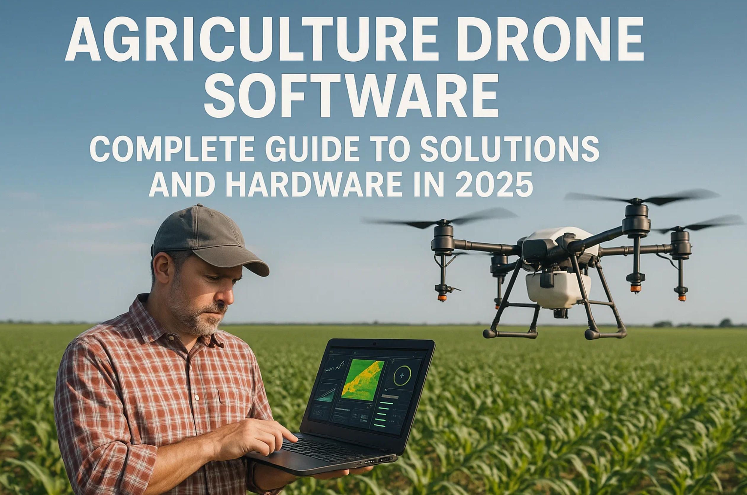
Agriculture Drone Software: Complete Guide to Solutions and Hardware in 2025
Custom Development Solutions from A-Bots.com
Agriculture drone software development requires deep expertise in both agricultural workflows and mobile technology. A-Bots.com specializes in building custom agriculture drone software solutions tailored to your specific operational needs. Whether you need a complete platform from scratch or integration with existing systems, our team delivers production-ready applications that streamline field operations, data collection, and analysis workflows.
Our app development company works with farms, cooperatives, and agricultural technology providers to create agriculture drone software that addresses real-world challenges. From prescription mapping interfaces to automated flight planning systems, we understand that drone applications must be reliable, intuitive, and capable of handling large datasets in offline environments. We develop for both iOS and Android platforms, ensuring your solution reaches operators regardless of their device preference.
Beyond new development, A-Bots.com offers comprehensive testing services for existing drone platforms. Our QA specialists conduct thorough testing across multiple device types, network conditions, and use cases to identify performance bottlenecks, usability issues, and potential failure points. This is particularly valuable for ag drone software that operates in remote locations where connectivity is unreliable and field conditions are demanding.
Whether you need to build a custom module for data analytics, develop integration with third-party mapping services like DJI Terra agriculture or pix4d agriculture, or modernize legacy systems, A-Bots.com brings the technical expertise and agricultural domain knowledge to deliver results. Our agile development process ensures rapid iteration and deployment, helping you bring solutions to market faster while maintaining quality standards that field operators demand.
Understanding the Drone Software Ecosystem for Modern Farming
The agriculture drone software landscape has matured significantly over the past several years. Modern platforms handle everything from flight planning and automated missions to advanced analytics and prescription generation. The software layer transforms raw drone data into actionable insights for agronomists, growers, and farm managers.
According to the Food and Agriculture Organization, global food production needs to increase by 70% to meet demand from a projected population of 9.7 billion by 2050. Agriculture drone software plays a critical role in achieving this goal through techniques that optimize resource use and maximize yields.
Today's agriculture drone software platforms typically include several core components: mission planning tools for automated flights, real-time data processing capabilities, vegetation index generation for crop health assessment, and integration with farm management systems. The best platforms support offline operation, recognizing that many agricultural areas lack reliable cellular connectivity. Solutions like DJI Terra agriculture and pix4d agriculture exemplify these capabilities.
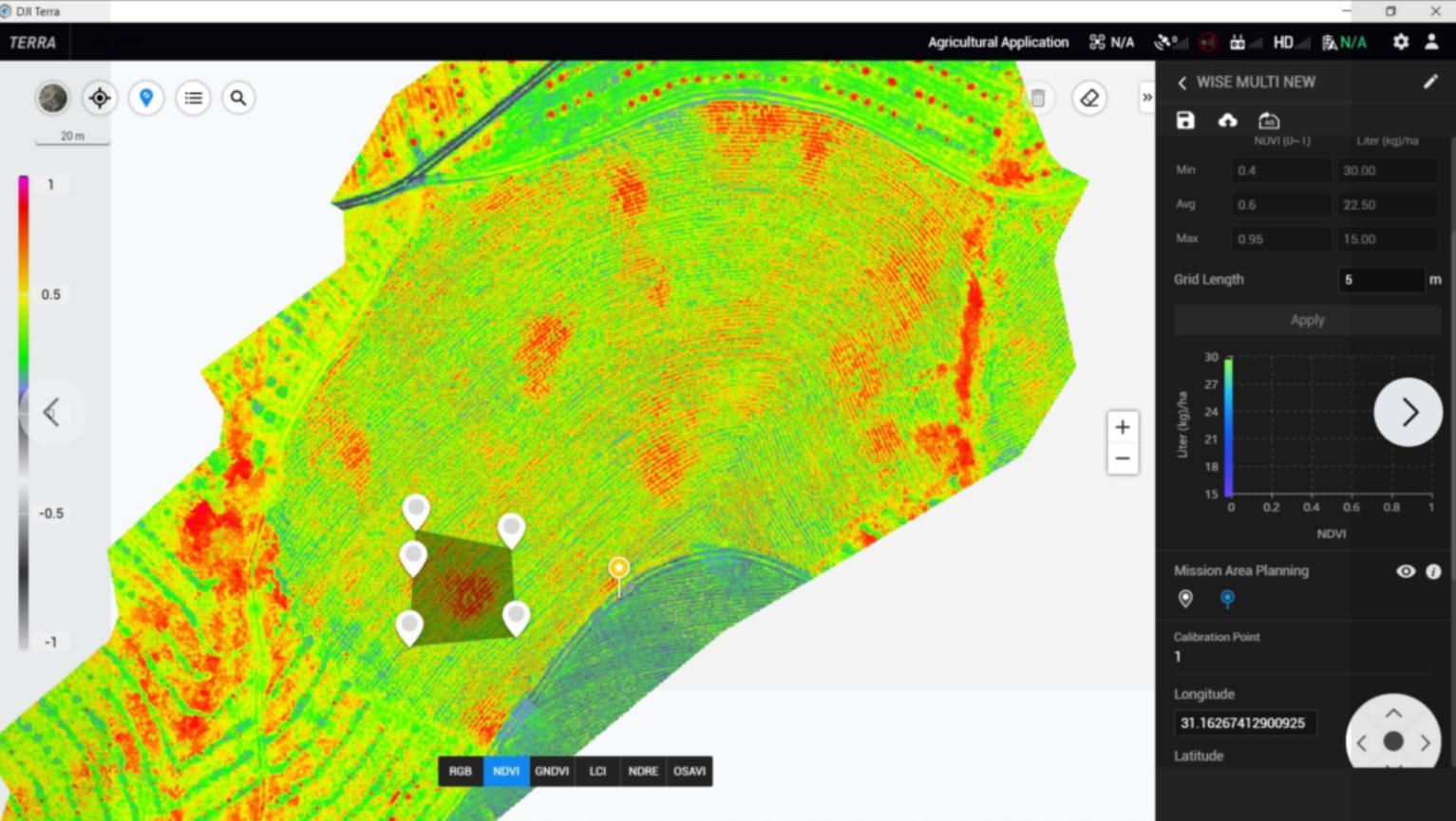
DJI Terra Agriculture: Desktop Power for Field Mapping
DJI Terra agriculture represents one of the most comprehensive mapping solutions for agricultural applications. This desktop-based platform processes data from DJI enterprise drones to create high-resolution 2D orthomosaics, 3D models, and vegetation index maps without requiring cloud connectivity.
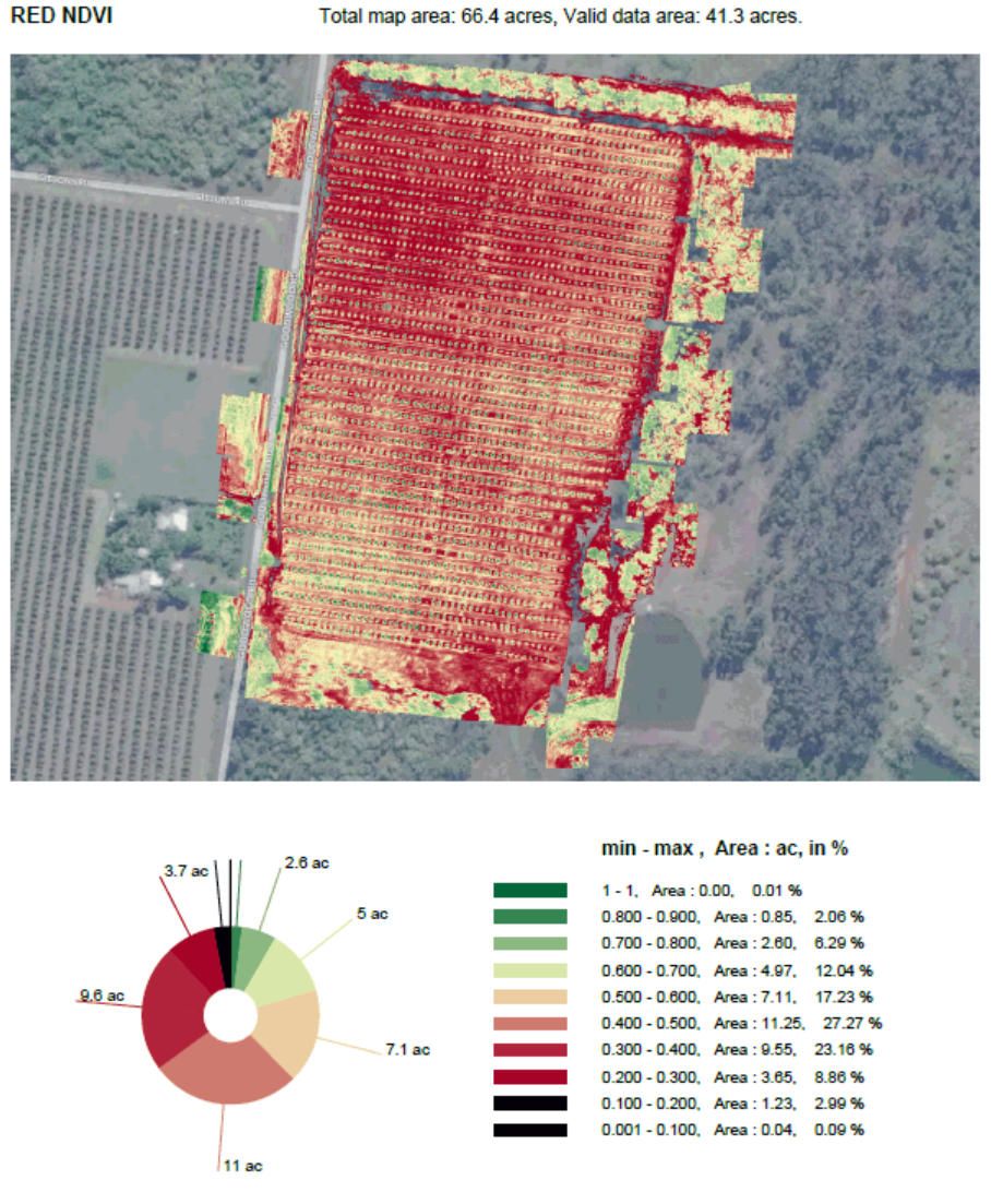
The agriculture-specific license of DJI Terra focuses on precision farming workflows. Users can generate NDVI (Normalized Difference Vegetation Index) maps to assess crop health, create terrain models for irrigation planning, and produce prescription maps for variable rate applications. The DJI Terra agriculture software processes multispectral imagery captured by drones like the DJI Mavic 3 Multispectral, combining data from green, red, red edge, and near-infrared bands.
One standout feature is the offline processing capability. Many drone platforms require internet connectivity for data upload and processing, but DJI Terra agriculture version operates entirely on local hardware. This is essential for operations in remote areas or when data security requires keeping information on-premises.
The software integrates seamlessly with DJI's Agras spray drones, enabling a complete workflow from field assessment to targeted application. Operators fly mapping missions with multispectral cameras, process the data in DJI Terra agriculture, generate prescription maps showing exactly where inputs are needed, and load those maps directly into spray drones for automated variable-rate application.
Processing speed depends on hardware specifications, but DJI Terra agriculture can handle large datasets efficiently. The software supports both standard photogrammetry workflows and advanced features like LiDAR data processing for users with the appropriate sensors. For agricultural operations requiring detailed terrain analysis or high-precision elevation models, these capabilities extend beyond basic crop monitoring.
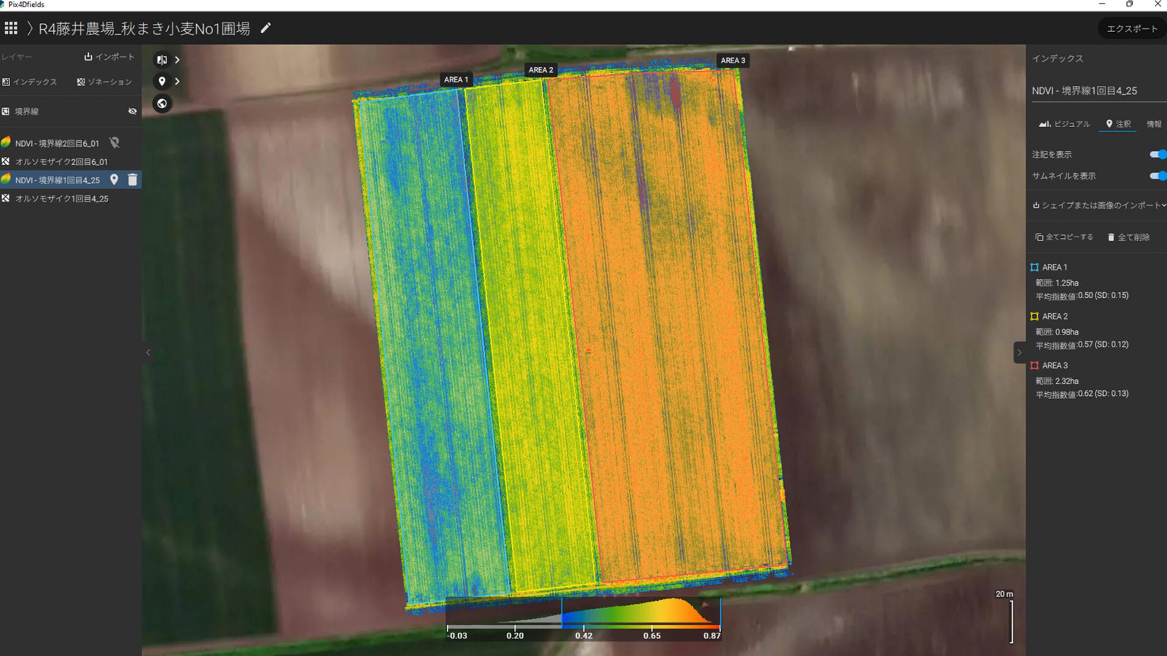
Pix4D Agriculture: Field-Edge Processing Excellence
Pix4D agriculture, specifically the PIX4Dfields platform, brings a different approach to drone mapping software. While DJI Terra agriculture emphasizes comprehensive 3D reconstruction, pix4d agriculture prioritizes speed and ease of use for agricultural-specific workflows. The software processes imagery rapidly, allowing agronomists to generate maps and insights while still in the field.
The instant processing engine in pix4d agriculture is particularly valuable for time-sensitive decisions. According to testimonials from users, the platform can process thousands of images in minutes, even on mid-range laptops. One user noted: "I was just amazed at the speed of the processing. I can work offline, so I can take pictures with the drone and process them on the spot."
PIX4Dfields supports both drone imagery and satellite data integration, giving users flexibility in data sources. The pix4d agriculture platform includes predefined vegetation indices and allows custom formula creation for specialized crop monitoring. The zonation tools aggregate index information into management zones, which can then be converted into variable rate prescription maps compatible with tractors, sprayers, and spray drones.
A standout feature is the Magic Tool, which uses AI to identify anomalies like weed patches, pest damage, or stressed areas in crop imagery. This dramatically reduces the time needed to create targeted spot-spraying maps. Turkish users implementing pix4d agriculture reported being "the first ones to achieve [variable rate applications] in Turkey" using the platform's prescription generation capabilities.
The software exports data in industry-standard formats including ISOXML and shapefiles, ensuring compatibility with John Deere Operations Center, Climate FieldView, and other farm management platforms. For operations already invested in specific farm management ecosystems, this interoperability is crucial for integrating pix4d agriculture into existing workflows.
DroneDeploy: Cloud-Based Mapping Platform
DroneDeploy offers a cloud-based approach that emphasizes accessibility and collaboration. The platform supports nearly any GPS-enabled drone, making it hardware-agnostic compared to manufacturer-specific solutions like DJI Terra agriculture. Agricultural customers have mapped over 310 million acres using DroneDeploy's platform.
The LiveMap feature addresses a common pain point in ag drone software: waiting for data processing. Instead of uploading gigabytes of images and waiting hours for results, LiveMap generates 2D orthomosaics in real-time during the flight. Operators can view and analyze maps at the field edge without internet connectivity, making immediate scouting decisions before leaving the site.
For stand count analysis, DroneDeploy partners with Corteva Agriscience to provide automated plant counting and emergence assessment. Eric Galdi, Global UAS Compliance Lead at Corteva, explained the impact: "We've heard countless stories from our sales and agronomists about how they used to scout 6 to 10 locations at 1/1000 of an acre, now they can sample 3 times more locations in the field at 100 times greater sample area all within 30 min."
The platform includes built-in plant health analysis tools for generating NDVI and other vegetation indices. These maps can be exported as shapefiles for creating nitrogen prescriptions in other agricultural software applications. The platform also supports comparison tools for evaluating product performance across test plots throughout the growing season.
DroneDeploy's web-based interface enables team collaboration and data sharing through secure links and comprehensive project reports. For agricultural service providers working with multiple growers, this facilitates communication and documentation. The platform achieved ISO 27001 and SOC 2 Type 2 certifications, addressing data security concerns for enterprise agricultural operations.
Agremo: AI-Powered Analytics Platform
Agremo takes a specialized approach to agricultural mapping, focusing on AI-powered analysis rather than basic map creation. The platform accepts imagery from any commercially available drone and sensor, then applies machine learning algorithms to identify, classify, and quantify patterns in crop data.
The AI capabilities extend beyond simple vegetation indices. Agremo can detect individual weeds in green-on-green scenarios, count plants with high accuracy for emergence and population analysis, identify disease and pest pressure zones, and assess frost damage extent. These analyses produce ready-to-use prescription maps for DJI Agras spray drones and other agricultural machinery.
Agricultural experts train and supervise the AI models using real customer data, ensuring the algorithms recognize actual field conditions rather than laboratory scenarios. This expertise-driven approach addresses a common limitation in drone mapping: the gap between generic image processing and agronomic interpretation.
Processing happens in Agremo's cloud infrastructure, with results delivered as shapefiles, PDFs, and CSV files. The platform provides variable rate application maps in formats compatible with both ground equipment and spray drones. For weed management specifically, the system generates high-resolution spot-spraying maps that can reduce herbicide use dramatically while maintaining efficacy.
Turkish agriculture professionals using Agremo noted that the AI-powered recipe maps make the DJI Agras drone "a truly intelligent and precise spraying tool" by enabling true prescription applications rather than uniform coverage. This integration between mapping platforms like Agremo, DJI Terra agriculture, and pix4d agriculture with application hardware represents the future of precision agriculture workflows.
Botlink: Automated Workflows for Agriculture
Botlink provides software designed for simplicity and automated workflows. The platform emphasizes reducing operator workload through intelligent flight planning and automated data processing. Agricultural users benefit from NDVI generation, plant health monitoring, and field change tracking over time.
The software architecture supports multiple drone types including fixed-wing, multirotor, and VTOL platforms. This flexibility allows operators to select the appropriate aircraft for specific jobs rather than being locked into a single hardware ecosystem. Profiles can be saved for quick switching between different drones based on operational requirements.
Integration with third-party farm management platforms is a core feature. Botlink exports to AgLeader SMS and agX SST agriculture software, streamlining data flow from aerial collection to field application. This addresses a common friction point in adoption: data silos that prevent actionable insights from reaching farm equipment operators.
The platform includes annotation and measurement tools for documenting field conditions and sharing findings with clients and colleagues. For agricultural consultants and service providers, these collaboration features support professional reporting and recommendation development. The web-based interface organizes imagery and analytical results for long-term field monitoring and comparison.

Agricultural Drone Hardware: Mapping and Monitoring
Understanding agriculture drone software requires familiarity with the hardware platforms that collect the data. Mapping and monitoring drones capture imagery and sensor readings that feed into processing pipelines like DJI Terra agriculture and pix4d agriculture. These platforms prioritize flight time, coverage area, and sensor payload capacity over spray capability.
DJI Mavic 3 Multispectral
The DJI Mavic 3 Multispectral represents the current standard for agricultural mapping. This compact drone combines a 20MP RGB camera with four 5MP multispectral cameras capturing green, red, red edge, and near-infrared wavelengths. The integrated RTK module provides centimeter-level positioning without ground control points.
Flight endurance reaches 43 minutes under ideal conditions, enabling coverage of approximately 200 hectares per flight. The built-in sunlight sensor captures solar irradiance data, allowing ag drone software to compensate for lighting variations between flights and produce more consistent NDVI results over time.
The Mavic 3 Multispectral works with DJI Terra agriculture, pix4d agriculture, and other agriculture drone software platforms that support multispectral data processing. Its portability makes it practical for agronomists and scouts who need to assess multiple locations in a single day. The terrain-following capability is particularly valuable for orchards and vineyards on sloped terrain.
senseFly eBee X
For large-area mapping, fixed-wing drones like the senseFly eBee X offer advantages in coverage efficiency. This platform can map 500 acres in a single flight, making it practical for commodity crop operations where fields measure in hundreds or thousands of acres. The eBee X supports multiple camera payloads including RGB, multispectral, and thermal sensors.
The fixed-wing design provides longer endurance and faster ground speed compared to multirotor platforms. This translates to more acres covered per battery and per day of operation. For ag drone software focused on field-scale crop monitoring, the eBee X delivers the data volume needed for comprehensive analysis.
WingtraOne Gen II
The WingtraOne offers a hybrid approach with VTOL (vertical takeoff and landing) capability combined with fixed-wing efficiency. This drone doesn't require a launcher or landing strip, making it more practical for diverse agricultural sites. The platform captures high-resolution imagery suitable for detailed crop health analysis and field mapping.
Professional surveyors and agricultural consultants use the WingtraOne when accuracy and coverage both matter. The agriculture drone software ecosystem supports this platform through standard image formats and georeferencing data, ensuring compatibility with processing workflows in DJI Terra agriculture, pix4d agriculture, and other platforms.
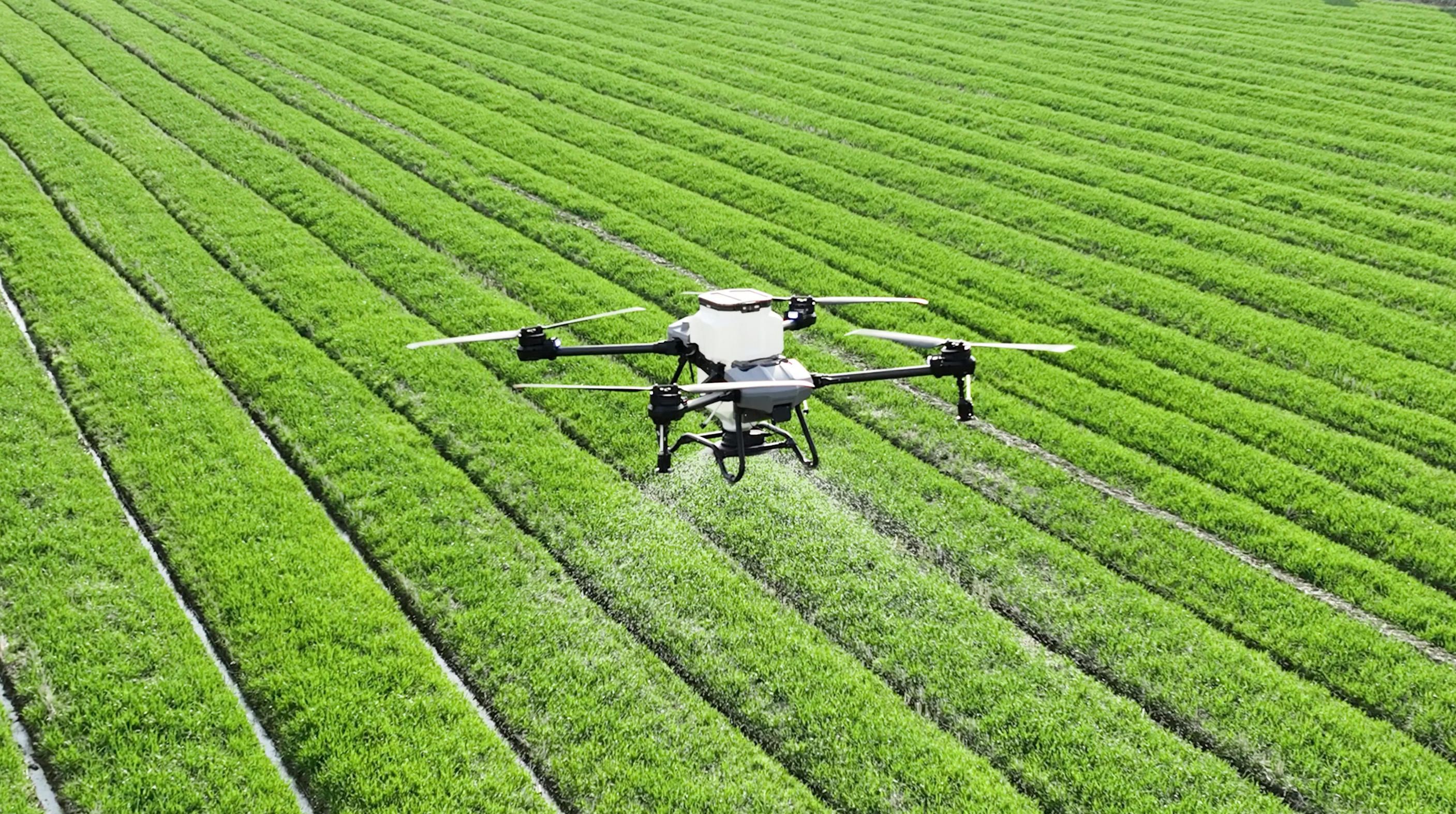
Agricultural Drone Hardware: Spraying and Application
Application drones represent a distinct category from mapping platforms. These aircraft prioritize payload capacity, spray system performance, and precise flight control for targeted chemical delivery. Modern spray drones integrate directly with agriculture drone software platforms like DJI Terra agriculture for prescription-based variable rate applications.
DJI Agras Series
DJI dominates the agricultural spray drone market with the Agras line. The latest models include the T100, T70P, and T50, each targeting different operation scales. Yuan Zhang, Head of Global Sales at DJI Agriculture, stated: "With nearly 500,000 trained operators worldwide as of May, the industry is maturing, and the demand for spray drones continues to grow annually."
The Agras T100 represents the flagship model with 100-liter spray capacity and 150-liter spreading capacity. Advanced safety systems including LiDAR, millimeter-wave radar, and omnidirectional vision sensors enable operation in complex orchard and terrain environments. The drone can carry 100 kg for lifting operations, expanding beyond traditional spray applications.
The T50, positioned for mid-to-large operations, offers efficient coverage at speeds up to 20 m/s. Integration with DJI Terra agriculture and DJI SmartFarm enables complete workflows from field assessment through prescription mapping to automated application. The agriculture drone software generates detailed flight paths that the aircraft follows autonomously, adjusting application rates based on prescription zones.
Smaller operations benefit from the T25P with its compact, foldable design suitable for solo operators. Despite the reduced size, this platform includes the spreading system and safety features found on larger models. The ability to program autonomous missions makes it practical for one person to manage multiple fields efficiently.
XAG Agricultural Drones
XAG Co., Ltd. offers competitive agriculture drone software and hardware from China. The P150 model features an 18.5-gallon tank and maximum flight speeds exceeding 30 mph, making it "the largest and fastest spray drone currently available on the market" according to retailers. The hybrid propulsion system combines electric motors with extended endurance options.
XAG received recognition from the Food and Agriculture Organization for best practices in sustainable plant production. The company's smart agriculture approach integrates spray drones with autonomous tractors and IoT field sensors, creating an ecosystem of automated tools. This system-level thinking extends to the ag drone software, which coordinates multiple pieces of equipment for complete farm automation.
The swarm intelligence capability allows coordinated fleets of 20+ drones to cover 1,000 acres daily when working together. This represents a significant scaling advantage for large operations or service providers covering multiple farms. The agriculture drone software manages mission coordination, preventing conflicts while maximizing coverage efficiency.
Hylio Agricultural Systems
Hylio represents the leading American manufacturer of agricultural spray drones, addressing concerns about supply chain security and regulatory compliance. The Texas-based company produces NDAA-compliant aircraft with all critical components sourced from approved suppliers outside China, Russia, and Iran.
The AG-272 model features a 38-liter spray tank and 40-foot swath width, capable of covering 50+ acres per hour. Unlike DJI's proprietary ecosystems, Hylio provides open platforms that customers can service and customize. Fleet management ag drone software allows operators to dispatch, monitor, and log multiple missions from a centralized dashboard.
Arthur Erickson, Hylio's CEO, emphasized the labor efficiency: "If you can imagine doing 50 acres or 60 acres per hour with one Hylio drone, you could almost multiply that linearly by having two or three." The company received the first FAA approval for single-operator control of three autonomous spray drones operating simultaneously, demonstrating regulatory acceptance of advanced agricultural automation.
The newer HYL-150 ARES pushes boundaries with 110-pound liquid capacity and application rates enabling hundreds of acres daily. For large-scale operations requiring rapid treatment, this heavy-lift platform competes directly with traditional ground equipment and crop dusters while offering precision advantages.
Integration with Farm Management Systems
Modern agriculture drone software platforms rarely operate in isolation. Integration with farm management systems, precision agriculture platforms, and equipment telematics creates cohesive data ecosystems. These connections allow drone-collected data to inform variable rate prescriptions, treatment records, and yield analysis.
John Deere Operations Center represents a major integration target for ag drone software. Platforms like DroneDeploy, pix4d agriculture, and DJI Terra agriculture offer direct export functionality, allowing vegetation index maps and prescription zones to flow seamlessly into equipment-native workflows. Justin Metz from Bowles Farming Company described the value: "It provides another layer of information and organizes it all into one place."
Climate FieldView compatibility extends the reach of ag drone software to users already invested in that ecosystem. By maintaining standard file formats and protocols, platforms like pix4d agriculture avoid forcing users to abandon existing investments in other precision agriculture tools. This interoperability accelerates adoption by reducing switching costs.
Equipment connectivity protocols like ISOXML ensure prescription maps generated in agriculture drone software platforms like DJI Terra agriculture or pix4d agriculture transfer correctly to spray booms, spreaders, and other implements. When rates and boundaries translate accurately, the precision benefits of aerial assessment materialize in actual field application. Errors in this translation negate the advantages of detailed mapping.
Real-Time Processing and Edge Computing
The trend toward field-edge processing reflects agricultural realities: connectivity is unreliable and immediate decisions matter. Modern platforms increasingly support local processing on laptops or tablets, generating results within minutes of landing rather than hours after uploading to cloud servers.
Pix4d agriculture emphasizes this capability, processing 2,948 images (6.8 GB) in approximately 10 minutes using the radiometry module. This speed enables agronomists to validate results before leaving the field, ensuring data quality and completeness. If issues appear, additional flights can capture missing coverage or problem areas immediately.
DroneDeploy's LiveMap takes real-time processing further by generating orthomosaics during the flight itself. The platform reconstructs imagery as the aircraft captures photos, providing a near-instant map for review. This immediate feedback helps operators identify areas requiring closer inspection or additional documentation.
The computational requirements for field-edge processing have decreased as algorithms improve and hardware becomes more powerful. Mid-range laptops with dedicated GPUs can now handle tasks that previously demanded workstation-class systems. This democratization makes sophisticated platforms like DJI Terra agriculture and pix4d agriculture accessible to smaller operations and independent consultants.
Data Security and Regulatory Compliance
Agricultural data represents valuable intellectual property and competitive information. Growers rightly concern themselves with who accesses their field data and where it resides. Agriculture drone software platforms must address these security considerations while maintaining functionality and ease of use.
On-premises processing options like DJI Terra agriculture eliminate data transmission concerns entirely. All imagery and results stay on operator hardware, never touching external servers. This approach appeals to operations with strict data governance requirements or concerns about cloud service provider access.
Cloud-based agriculture drone software platforms like DroneDeploy and pix4d agriculture implement encryption, access controls, and compliance certifications to protect customer data. ISO 27001 and SOC 2 Type 2 certifications demonstrate adherence to information security standards. Data residency options, with servers in specific regions, address jurisdictional concerns about data location.
Regulatory frameworks continue evolving for agricultural drone operations. FAA regulations in the United States require Part 107 certification for commercial drone pilots and may require additional Part 137 certification for agricultural applications. The ag drone software ecosystem adapts to these requirements through compliance documentation, training programs, and operational guidelines.
NDAA compliance considerations affect government contractors and organizations with security requirements. Chinese-manufactured drones face restrictions in certain applications, driving interest in alternatives like Hylio's American-made platforms. The ag drone software landscape reflects this dynamic with solutions supporting multiple hardware vendors rather than locking users into specific manufacturers.
Future Developments in Precision Farming Software
The agriculture drone software sector continues rapid development. Several trends point toward future capabilities that will further enhance precision agriculture workflows and operational efficiency.
Artificial intelligence and machine learning integration will deepen beyond current capabilities. While platforms like Agremo already use AI for analysis, future agriculture drone software will provide predictive insights, forecasting pest pressure, disease spread, and yield potential based on historical patterns and current observations. These predictions enable proactive rather than reactive management.
Autonomous swarm operations represent scaling opportunities for large operations. Current regulations limit single-operator control to small numbers of aircraft, but technology enables coordination of much larger fleets. As regulatory frameworks mature, ag drone software platforms like DJI Terra agriculture will orchestrate dozens of drones simultaneously, dramatically increasing coverage capability.
Integration with ground robotics and autonomous tractors creates comprehensive farm automation ecosystems. XAG's approach of combining aerial drones with autonomous ground vehicles demonstrates this direction. Agriculture drone software platforms like DJI Terra agriculture and pix4d agriculture become the coordination layer for multiple automated systems working in concert across the farm.
Enhanced sensor capabilities will expand data collection beyond current RGB and multispectral imaging. Hyperspectral sensors, improved thermal cameras, and LiDAR systems provide richer datasets for analysis. Agriculture drone software must evolve to process these new data types and extract actionable insights relevant to agronomic decision-making.
Selecting the Right Platform for Your Operation
Choosing appropriate agriculture drone software depends on specific operational requirements, existing technology investments, and workflow preferences. Several factors guide the selection process for farms, cooperatives, and agricultural service providers.
Processing location determines whether cloud-based or desktop solutions fit better. Operations with reliable connectivity and preference for remote access benefit from cloud platforms like DroneDeploy. Users in areas with limited internet or data security concerns favor offline agriculture drone software solutions like DJI Terra agriculture or pix4d agriculture local processing.
Hardware compatibility matters when existing drone investments constrain options. Manufacturer-specific platforms like DJI Terra agriculture integrate seamlessly with company hardware but may not support other brands. Hardware-agnostic ag drone software platforms like pix4d agriculture and DroneDeploy work with various drones but may lack deep integration with specific features.
Analysis depth requirements vary by operation. Basic vegetation index generation satisfies many crop monitoring needs, while specialized applications like weed detection or plant counting demand advanced AI capabilities. Platforms like Agremo focus on these detailed analyses, while general-purpose ag drone software solutions like DJI Terra agriculture and pix4d agriculture provide broader but shallower analytical tools.
Integration with existing farm management systems influences software selection. Operations invested in John Deere, Climate FieldView, or other platforms need compatible solutions that export data correctly. Checking integration capabilities before committing prevents workflow friction and data silos.
Cost Considerations for Drone Mapping Platforms
Pricing models for agriculture drone software range from perpetual licenses to monthly subscriptions and per-use fees. Understanding the total cost requires evaluating not just license fees but also hardware requirements, training needs, and ongoing support costs.
Desktop agriculture drone software like DJI Terra agriculture typically sells as annual licenses, with agriculture versions starting around $800-1,500 per year. The software requires capable PC hardware with discrete graphics cards, adding to total costs if existing computers lack sufficient specifications. These one-time hardware investments amortize over multiple years.
Cloud-based ag drone software platforms often use subscription pricing, with costs scaling based on features and usage volume. Entry-level plans may start at $99-299 monthly, while professional tiers with advanced analytics and API access range into thousands monthly. The advantage lies in predictable costs and elimination of hardware upgrade requirements.
Service-based models where drone operators handle flights and analysis create different economics. Growers pay per-acre fees typically ranging from $3-10 depending on analysis complexity and turnaround requirements. This removes capital investment but creates ongoing operational costs. For operations flying occasionally, the service model often proves more economical than investing in agriculture drone software platforms like DJI Terra agriculture or pix4d agriculture and operator training.
Training costs deserve consideration regardless of software choice. Effective use of platforms like DJI Terra agriculture or pix4d agriculture requires understanding both the technical operation and agronomic interpretation of results. Manufacturer training programs, online courses, and consulting services help new users achieve proficiency. Time investment during the learning curve affects initial productivity.
The Role of Custom Development
While commercial platforms serve many needs, custom development addresses unique requirements that off-the-shelf solutions cannot accommodate. Operations with specialized crops, proprietary methodologies, or integration with legacy systems benefit from tailored applications.
Custom development enables precise workflow matching. Rather than adapting operations to software limitations, custom solutions adapt to existing processes. This reduces training requirements and maintains operational efficiency during technology adoption. Companies like A-Bots.com specialize in understanding agricultural workflows and building software that fits naturally into them.
Integration flexibility represents another advantage of custom solutions. While commercial platforms like pix4d agriculture offer standard integrations, custom development can connect with any system regardless of API availability or compatibility. This proves valuable for operations using specialized equipment, proprietary farm management platforms, or scientific research systems requiring specific data formats.
Intellectual property protection motivates some organizations toward custom development. Proprietary analysis algorithms, specialized indices, or unique analytical methods remain confidential when implemented in custom rather than commercial platforms. This allows competitive advantage maintenance in agricultural service provision or research applications.
Long-term cost control can favor custom development for high-volume users. While upfront development costs exceed commercial license fees, eliminating recurring subscription expenses eventually creates savings. Organizations with in-house IT capabilities to maintain custom applications often find this approach cost-effective over multi-year horizons.
Conclusion
The precision farming software ecosystem has become essential infrastructure for modern agriculture. From field-edge processing platforms like pix4d agriculture to comprehensive mapping solutions like DJI Terra agriculture, the ecosystem offers tools for operations of all scales. Cloud-based options like DroneDeploy democratize access through low barriers to entry, while specialized platforms like Agremo push analytical capabilities with AI-powered insights.
The hardware landscape has matured alongside software, with mapping drones like the Mavic 3 Multispectral providing multispectral data collection and spray drones like the Agras series enabling precision application. American manufacturers like Hylio offer alternatives for operations requiring supply chain security, while Chinese leaders DJI and XAG drive advancement in automation and swarm operations.
Selecting appropriate solutions requires evaluating processing location preferences, hardware compatibility, analytical depth needs, and integration requirements. Cost considerations extend beyond license fees to include hardware, training, and workflow adaptation expenses. For unique requirements, custom development provides flexibility and intellectual property protection that commercial platforms cannot match.
A-Bots.com stands ready to support agricultural operations with custom development, integration services, and comprehensive testing solutions for agriculture drone software. Whether building new applications with capabilities rivaling DJI Terra agriculture and pix4d agriculture, modernizing existing systems, or ensuring quality through rigorous testing, our expertise in ag drone software delivers results that work in real field conditions. Contact our team to discuss how custom development can address your specific precision agriculture technology needs.
Sources:
- DJI Agriculture Official Website: https://ag.dji.com
- PIX4D Agriculture Solutions: https://www.pix4d.com/product/pix4dfields
- Food and Agriculture Organization (FAO): https://www.fao.org
- Mordor Intelligence Agriculture Drones Market Report (2025)
✅ Hashtags
#DroneMapping
#SmartFarming
#AgTech
#PrecisionFarming
#CropMonitoring
#DroneAgriculture
#FarmTechnology
#AgriculturalDrones
#NDVIMapping
#VariableRateApplication
#DJIAgras
#MultispectralMapping
#FarmAutomation
#AgriculturalInnovation
#CustomSoftwareDevelopment
Other articles
Custom Agriculture App Development for Farmers In 2024, U.S. farmers are more connected than ever — with 82% using smartphones and 85% having internet access. This article explores how mobile applications are transforming everyday operations, from drone-guided field scouting to livestock health tracking and predictive equipment maintenance. It examines why off-the-shelf apps often fail to address specific farm needs and how collaborative, farmer-funded app development is gaining momentum. Through real-world examples and step-by-step guidance, readers will learn how communities of growers can fund, design, and launch custom apps that fit their exact workflows. A-Bots.com offers tailored development services that support both solo farmers and agricultural groups. With offline capabilities, modular design, and support for U.S. and international compliance, these apps grow alongside the farm. Whether you're planting soybeans in Iowa, raising cattle in Texas, or running a greenhouse in California — this article offers the tools and inspiration to build your own farm technology. Discover why more farmers are saying: we don’t wait for the future — we build it.
Custom Drone Mapping Software & Control Apps: Smarter Aerial Solutions by A-Bots.com Custom drone software is revolutionizing how industries operate—from precision agriculture to infrastructure inspection. This article explores why off-the-shelf apps fall short, how AI and modular design shape the future, and how A-Bots.com delivers tailored drone solutions that truly fit. Whether you manage crops, assets, or entire projects, the right software lifts your mission higher.
Drone Mapping Software (UAV Mapping Software): 2025 Guide This in-depth article walks through the full enterprise deployment playbook for drone mapping software or UAV mapping software in 2025. Learn how to leverage cloud-native mission-planning tools, RTK/PPK data capture, AI-driven QA modules and robust compliance reporting to deliver survey-grade orthomosaics, 3D models and LiDAR-fusion outputs. Perfect for operations managers, survey professionals and GIS teams aiming to standardize workflows, minimize field time and meet regulatory requirements.
ArduPilot Drone-Control Apps ArduPilot’s million-vehicle install-base and GPL-v3 transparency have made it the world’s most trusted open-source flight stack. Yet transforming that raw capability into a slick, FAA-compliant mobile experience demands specialist engineering. In this long read, A-Bots.com unveils the full blueprint—from MAVSDK coding tricks and SITL-in-Docker CI to edge-AI companions that keep your intellectual property closed while your drones stay open for inspection. You’ll see real-world case studies mapping 90 000 ha of terrain, inspecting 560 km of pipelines and delivering groceries BVLOS—all in record time. A finishing 37-question Q&A arms your team with proven shortcuts. Read on to learn how choosing ArduPilot and partnering with A-Bots.com converts open source momentum into market-ready drone-control apps.
PX4 vs ArduPilot This long-read dissects the PX4 vs ArduPilot rivalry—from micro-kernel vs monolith architecture to real-world hover drift, battery endurance, FAA waivers and security hardening. Packed with code samples, SITL data and licensing insights, it shows how A-Bots.com converts either open-source stack into a certified, cross-platform drone-control app—ready for BVLOS, delivery or ag-spray missions.
Mastering the Best Drone Mapping App From hardware pairing to overnight GPU pipelines, this long read demystifies every link in the drone-to-deliverable chain. Learn to design wind-proof flight grids, catch RTK glitches before they cost re-flights, automate orthomosaics through REST hooks, and bolt on object-detection AI—all with the best drone mapping app at the core. The finale shows how A-Bots.com merges SDKs, cloud functions and domain-specific analytics into a bespoke platform that scales with your fleet.
Farmer App Development Company - Smart Farming Apps and Integrations Looking for an app for agriculture that crews will actually open at dawn? A-Bots.com builds lean, offline-first farming applications that slot into what you already run—John Deere Operations Center, Climate FieldView, Trimble—so plans flow into cabs and clean records flow back. As a specialist farmer app development company, we start with a nucleus that pays back quickly: tasks that close the loop, imagery/weather signals that become guided tickets, and auditor/buyer-ready exports. Then we expand through a plugin architecture—labor & QC for orchards and berries, virtual fencing & grazing timelines, or contract-aware traceability/carbon modules—without breaking operator muscle memory. Your smart farming app comes with plain-language data contracts (who sees what, for how long, and why), one-tap export/revocation, and role-based access for advisors, landlords, and buyers. Serving the US, Canada, Scandinavia, and EU, we respect mixed fleets and regional policy, mapping to ADAPT/ISOBUS and EU data expectations by design. Budget tight? We help structure cooperative or buyer-aligned crowdfunding so critical plugins ship sooner—under clear ownership. Build beside the best farmer apps, not against them—and turn season pressure into repeatable wins.
Top stories
Copyright © Alpha Systems LTD All rights reserved.
Made with ❤️ by A-BOTS