Home
Services
About us
Blog
Contacts
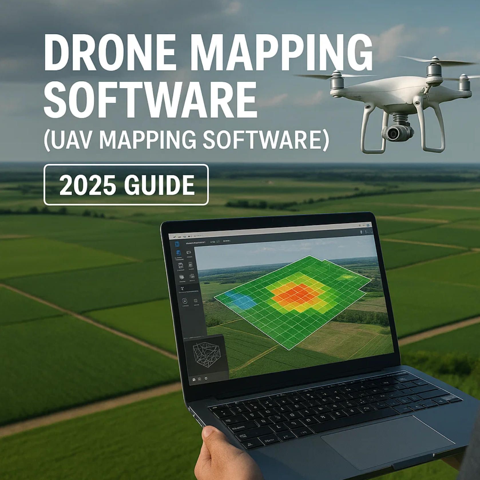
Drone Mapping Software (UAV Mapping Software): 2025 Guide
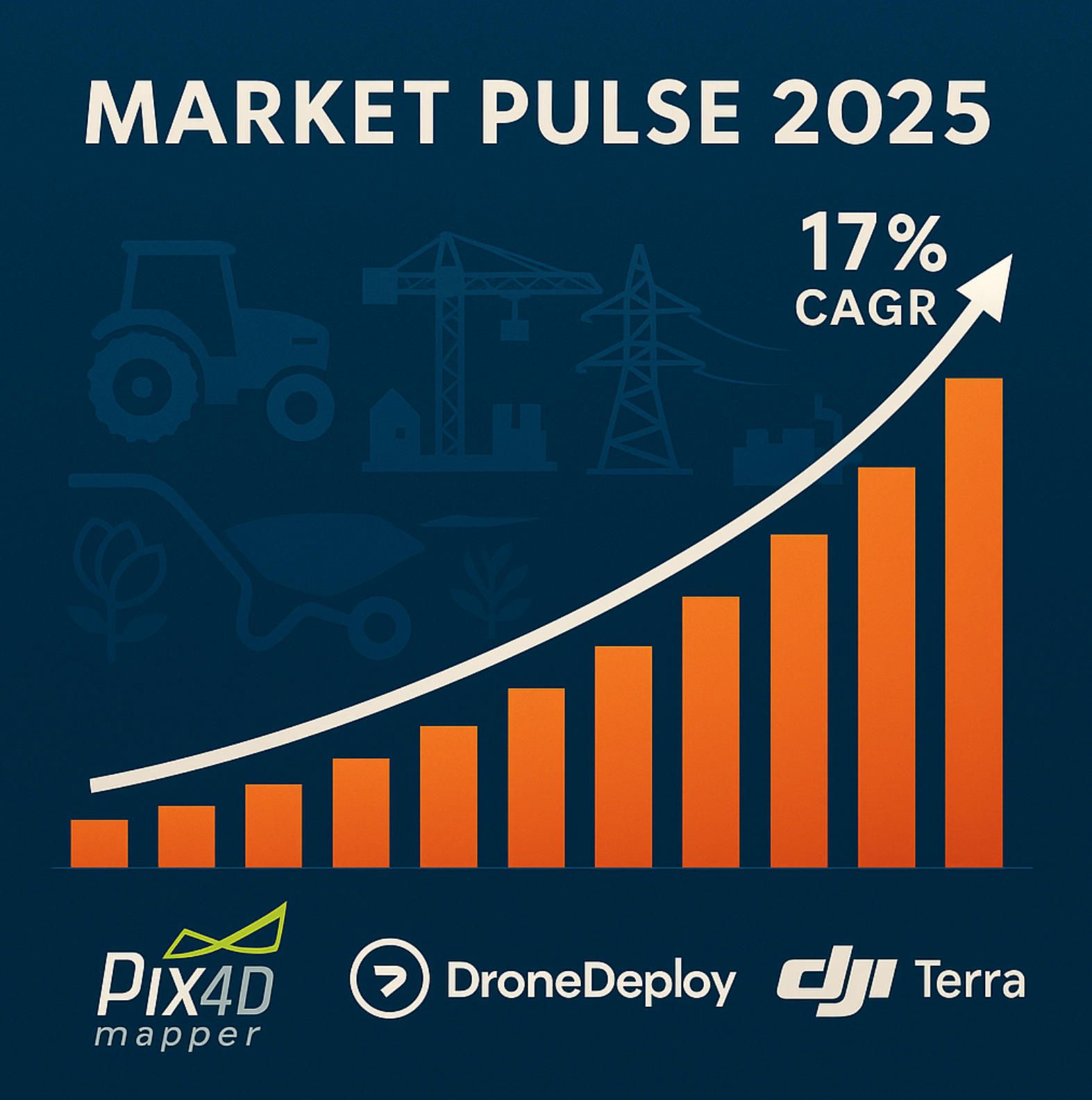
1. Market Pulse 2025: Why Drone Mapping Software Is Scaling at 17% CAGR
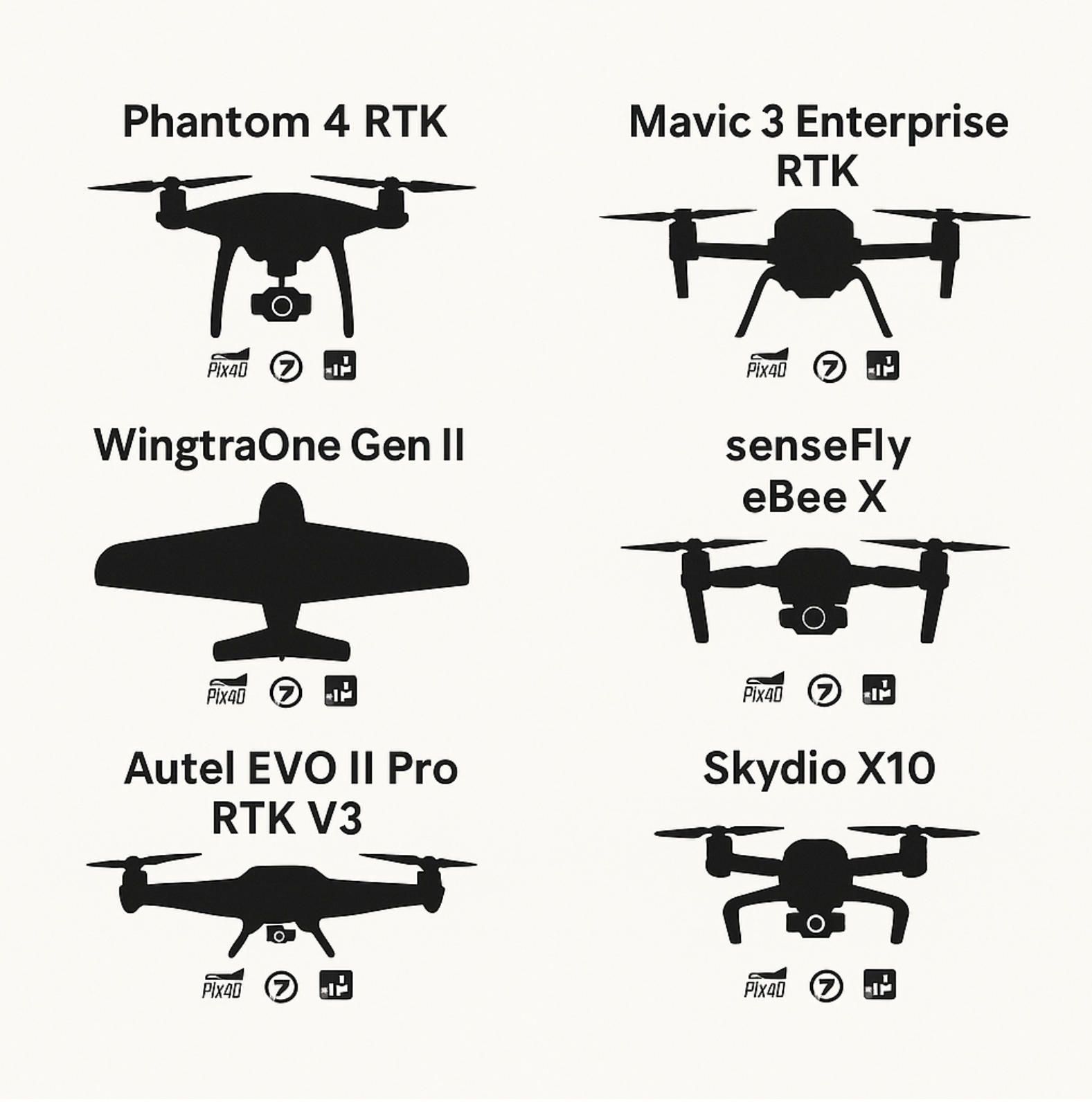
2. Hardware Stack: The Seven Most‑Deployed Mapping UAVs in 2024‑25
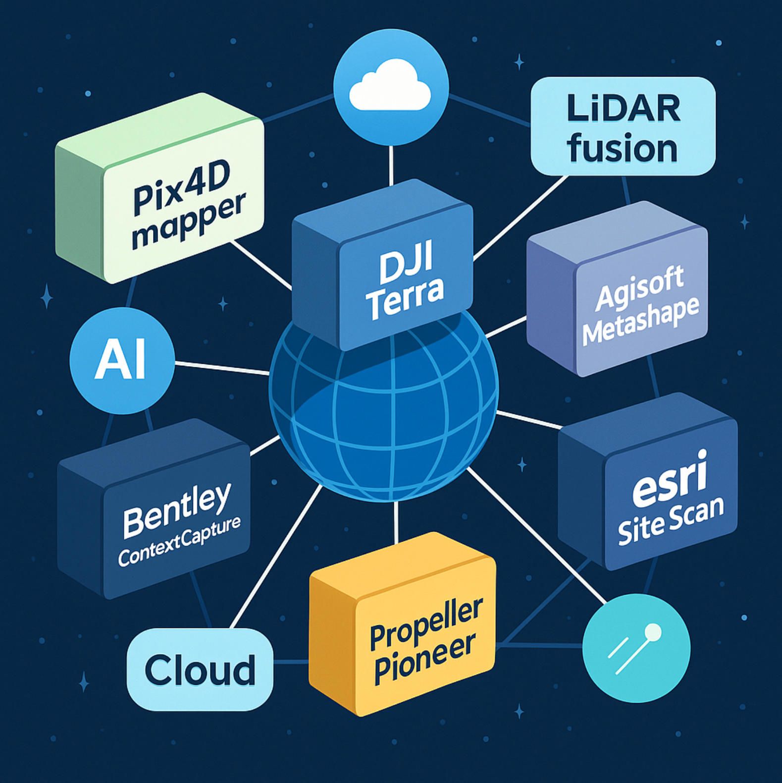
3. Software Arsenal: Comparing the Big‑Seven Suites Shaping UAV Mapping Software
4. Mapping Methodologies: Photogrammetry, LiDAR & Next‑Gen SLAM Engines
5. Enterprise Deployment Playbook: From Mission Planning to QA & Compliance
Market Pulse 2025: Why Drone Mapping Software Is Scaling at 17% CAGR
In 2025, the drone mapping software segment is surging ahead of the broader drone-software market thanks to a confluence of technological advances and expanding end-user demand. According to Fact.MR, the global drone-mapping‐software market is projected to hit USD 1.3 billion by year-end, growing at a 17.1 % CAGR since 2020 by Fact.MR. Meanwhile, MarketsandMarkets reports that the total drone software market will more than double from USD 5.1 billion in 2022 to USD 11.2 billion by 2027, also at a 17.1 % CAGR MarketResearch. Within that ecosystem, mapping-focused suites are even hotter: The Insight Partners estimates a 20.1 % CAGR for drone mapping software from 2025 to 2031 The Insight Partners. By contrast, broader forecasts from Fortune Business Insights and Verified Market Research put overall drone-software CAGRs at 32 % (2019–2032) and 26.83 % (2026–2032), respectively.
Market Size & Growth Trajectory
The standalone drone mapping software slice — encompassing orthomosaics, 3D reconstruction, LiDAR fusion and analytics — is outpacing adjacent segments such as fleet management and real-time telemetry. Fact.MR’s estimate of USD 1.3 billion in 2025 represents a near-tripling since 2020. Meanwhile, The Insight Partners forecasts that segment revenues will continue climbing at over 20 % CAGR through 2031, driven by steady enterprise adoption.
In parallel, the total drone software market (flight-planning, analytics, mapping, fleet-ops) is on track to reach USD 11.2 billion by 2027, up from USD 5.1 billion in 2022, per MarketsandMarkets. Fortune Business Insights projects an even more aggressive expansion—USD 1.17 billion in 2019 ballooning to USD 43.04 billion by 2032 at 32 % CAGR. Verified Market Research concurs, forecasting growth to USD 82.94 billion by 2032 (26.83 % CAGR from 2026). These figures underscore that while drone mapping software is a fast-rising tide in its own right, it sits within a turbo-charged software ecosystem.
Key Growth Drivers
Several interlocking trends explain why organizations are pouring budgets into drone mapping software:
• Demand for Aerial Data & Automation. Stakeholders across construction, agriculture and energy crave rapid site intelligence. “Demand for aerial data, automation, and integration with AI and cloud computing” tops the list of growth factors cited by industry analysts.
• Cloud-Native, Collaborate-First Architectures. Cloud-based platforms eliminate heavy on-premise compute needs, letting teams spin up orthomosaic generation and 3D modeling jobs on-demand without local GPU clusters.
• Private Investment & Infrastructure Use-Cases. Growing private funding for UAS ventures and an uptick in infrastructure-inspection pilots (bridges, pipelines, powerlines) are stoking software demand.
• Government & Enterprise Efficiency Drives. Fact.MR notes that “governments and companies alike are increasingly opting for drones for real-time decision-making, land evaluation, and preventive maintenance,” reducing field-survey costs and accelerating project timelines.
• Hybrid Photogrammetry–LiDAR Fusion. Combining imagery and LiDAR in mapping suites delivers sub-3 cm accuracy and superior visual realism under vegetation cover.
Forecast & Outlook
By 2027, drone mapping software is poised to command more than one-quarter of all drone software spend, as enterprises seek end-to-end surveying workflows that shrink in-field time by up to 80 % (via RTK/PPK methods) and accelerate processing with AI-driven plugins Fact.MR. Emerging edge-compute photogrammetry and real-time SLAM engines will push accuracy below 10 mm, further eroding traditional survey-tech barriers.
In this backdrop of robust 17 % CAGR growth, advancing algorithms and cloud-native suites, 2025 truly marks a watershed year for drone mapping software—the must-have toolkit for any organization serious about unlocking aerial data at scale.
Hardware Stack: The Seven Most-Deployed Mapping UAVs in 2024-25
Below is an overview of the seven most-widely deployed mapping UAVs in 2024-25, each paired with leading drone mapping software suites and key mapping methods. These platforms form the backbone of modern aerial surveying, combining endurance, sensor fidelity and workflow integration to meet diverse application needs.
DJI Phantom 4 RTK
The Phantom 4 RTK delivers up to 30 minutes of flight time on a single intelligent flight battery, enabling surveyors to capture expansive orthomosaics with minimal battery swaps DJI. It features a 1" CMOS, 20 MP sensor and TimeSync module, achieving an absolute photogrammetric accuracy of ≈ 5 cm in orthomosaic outputs. Integrated RTK/PPK positioning slashes ground-control-point requirements by up to 80 %—ideal for rapid corridor mapping via Structure-from-Motion photogrammetry. Commonly paired with Pix4Dmapper for AI-augmented photogrammetry and DJI Terra for seamless DJI-native processing, the Phantom 4 RTK remains a staple in precision-agriculture and small‐site surveying.
DJI Mavic 3 Enterprise RTK
The Mavic 3 Enterprise RTK offers a 45 minute maximum flight time (≈ 36 minutes in typical corridor-mission use), balancing portable form-factor with extended coverage. Its 4/3" CMOS, 20 MP wide-angle camera with mechanical shutter and 56× hybrid zoom module supports fine-grained mapping at higher altitudes, while centimeter-level RTK positioning ensures sub-5 cm geolocation accuracy DJI. This drone is often flown using DroneDeploy’s cloud-native mission planner and processed in Agisoft Metashape for dense point-cloud reconstruction or in Esri Site Scan for enterprise GIS integration.
DJI Matrice 350 RTK
Built for heavy-duty applications, the Matrice 350 RTK boasts a 55 minute flight endurance and an IP55 protection rating, tolerating harsh environments and prolonged sorties. Its open Payload SDK (PSDK) supports custom LiDAR modules and high-resolution cameras, making it a go-to for lidar-photogrammetry fusion workflows. Mapping professionals frequently load it with hybrid payloads and process data in Bentley ContextCapture for infrastructure-scale 3D meshes or in Pix4Dmapper for rapid orthomosaic turnarounds.
WingtraOne Generation II
The WingtraOne Gen II is a VTOL tailsitter design combining fixed-wing endurance (up to 59 minutes) with vertical take-off/landing convenience. Flight missions are planned in WingtraPilot, then data is exported to Pix4Dmatic or Agisoft Metashape for high-fidelity point-clouds and orthomosaics. Its tail-sit architecture and photogrammetry-optimized S.O.D.A. camera deliver consistent 1–2 cm GSD at scale, ideal for large-area topographic surveys using Structure-from-Motion methods.
senseFly eBee X
With an exceptional 90 minute flight time and S.O.D.A. 3 cam package, the eBee X maps up to 500 ha in one sortie, revolutionizing agricultural and environmental monitoring. Its built-in RTK/PPK compatibility further trims field-survey burdens, enabling sub-5 cm absolute accuracy without dense GCP grids. Data export pipelines include Propeller Pioneer for volumetric dashboards and DroneDeploy for collaborative orthomosaic sharing.
Autel EVO II Pro RTK V3
The EVO II Pro RTK V3 integrates a 1" 6K CMOS, 20 MP sensor with ultra-sensitive low-light algorithms, capturing crisp mapping datasets in demanding light conditions. Its RTK module yields 1 cm horizontal accuracy, and 36 minutes of real-world flight endurance secures reliable coverage for mid-sized sites. Survey teams often process imagery in Pix4Dmapper for AI-driven denoising or leverage Esri Site Scan for enterprise geodatabase delivery.
Skydio X10
Pioneering onboard SLAM, the Skydio X10 runs NVIDIA Jetson Orin SoC for real-time 3D mapping in GPS-denied zones, achieving < 5 cm drift in complex environments. Although its 40 minute flight time is shorter, its autonomous obstacle-avoidance ensures flawless corridor scans in confined spaces. Post-flight, Skydio’s point-clouds are refined in Pix4Dmatic or DroneDeploy, integrating visual-SLAM data with photogrammetry pipelines.
By pairing these workhorse UAVs with top-tier drone mapping software and tested mapping methods—photogrammetry (SfM/MVS), LiDAR fusion, and SLAM—survey professionals can tailor end-to-end workflows for any scale, environment or accuracy requirement.
Software Arsenal: Comparing the Big-Seven Suites Shaping UAV Mapping Software
In the rapidly evolving landscape of drone mapping software, seven flagship platforms dominate both desktop and cloud-native deployments. Each brings a unique combination of photogrammetry, LiDAR fusion, AI-powered automation and collaboration tools that together define today’s UAV mapping software benchmarks. Below, we compare Pix4Dmapper, DroneDeploy, DJI Terra, Agisoft Metashape, Bentley ContextCapture, Propeller Pioneer and Esri Site Scan across core capabilities, processing workflows, extensibility and pricing cues.
1. Pix4Dmapper (Pix4D)
Core Strengths:
- Advanced Photogrammetry: At the heart of Pix4Dmapper lies a proven Structure-from-Motion (SfM) and Multi-View Stereo (MVS) pipeline augmented by deep-learning denoising networks. Users routinely see orthomosaic noise reduction of up to 23% and point-cloud density gains of 15% compared to earlier releases.
- Plugin Ecosystem: With SDK hooks for Python scripting and seamless integration into GIS or CAD environments, Pix4Dmapper excels as extensible drone mapping software for custom workflows.
- Offline & Cloud: Offers a desktop edition for high-throughput on-premise GPUs alongside Pix4D Cloud for collaborative review, making it a hybrid solution in the UAV mapping software category.
- Pricing Cue: Subscriptions begin at roughly USD 350 per month, with perpetual license options available for enterprise accounts.
2. DroneDeploy (DroneDeploy Inc.)
Core Strengths:
- Cloud-First Collaboration: DroneDeploy pioneered cloud-native drone mapping software, enabling mission planning, processing and mark-up in a browser. Teams can invite stakeholders to annotate orthomosaics and 3D models in real time.
- Copilot™ AI QA Layer: Latest Copilot module automatically flags tie-point outliers and low-confidence mesh regions, cutting manual QA by 40%.
- Mobile Mission Control: Native apps for iOS and Android link directly to DJI and Autel hardware, streamlining UAV mapping software operations in the field.
- Pricing Cue: Starting at USD 329 per month for small teams; enterprise plans available with API access.
3. DJI Terra (DJI Enterprise)
Core Strengths:
- Tight UAV Integration: As the in-house companion for DJI drones (Matrice, Phantom, Mavic lines), Terra leverages TimeSync and RTK/PPK telemetry automatically, minimizing GCP density in photogrammetry workflows.
- EPSG Wizardry: Supports over 8 500 coordinate systems out of the box, plus a GCP import assistant—vital for global infrastructure projects.
- LiDAR Fusion: In its Advanced edition, DJI Terra ingests point-clouds from third-party LiDAR modules, unifying imagery and LiDAR into a single meshing engine.
- Pricing Cue: Perpetual license at approximately €3 000, with optional annual maintenance.
4. Agisoft Metashape 1.9 (Agisoft)
Core Strengths:
- Dense Point-Cloud Fidelity: Metashape’s GPU-accelerated MVS stage delivers mesh density and accuracy that rival offline research tools—ideal for heritage preservation and high-detail cultural-site surveys.
- Python API: Extensive scripting interface enables full automation of batch photogrammetry, custom report generation and integration into existing GIS pipelines.
- Deep-Learning Plugins: Optional neural-network modules for semantic segmentation and classification extend Metashape from pure drone mapping software into thematic mapping.
- Pricing Cue: One-time fee near USD 3 500 for the Standard edition; Professional edition with LiDAR support costs more.
5. Bentley ContextCapture (Bentley Systems)
Core Strengths:
- Infrastructure-Scale Meshing: Engineered for massive projects, ContextCapture can process over 50 000 images in a single job, fusing UAV imagery with terrestrial LiDAR scans for rail, road and bridge documentation.
- Hybrid Fusion Algorithms: Proprietary LiDAR-image registration yields seamless textures on large-scale 3D meshes, reducing post-processing by up to 60%.
- Enterprise Governance: Integrated with Bentley’s ProjectWise and iTwin platforms, it fits into organizations demanding strict data versioning and compliance.
- Pricing Cue: Available by quote; typically in the mid-five-figure range for perpetual licenses.
6. Propeller Pioneer (Propeller Aero)
Core Strengths:
- Earthworks & Volumetrics: Specialized dashboards calculate cut/fill volumes, material stockpiles and progress tracking in seconds, with automated grid-based error analysis.
- Autogrid™ PPK Validation: Unique post-processing checks verify PPK baselines and alert operators to drift anomalies before delivering final deliverables.
- Team-Centric UX: Designed as a “one-click” drone mapping software platform, Pioneer emphasizes ease of use for site engineers and project managers.
- Pricing Cue: Pay-per-project starts at USD 250, or subscription tiers for high-volume users.
7. Esri Site Scan (Esri)
Core Strengths:
- ArcGIS Ecosystem: As part of the broader ArcGIS platform, Site Scan inherits robust spatial analysis, enterprise security and user-management features.
- Real-Time Inspection: Live streaming of orthomosaic updates supports immediate inspections and decision-making on active sites—crucial for asset-intensive industries.
- Custom Workflows: Through ArcGIS Notebook integration, Site Scan workflows can be scripted end-to-end, from flight planning to post-processing and final map publication.
- Pricing Cue: Starts at USD 495 per month for basic plan; enterprise bundles vary by user count and geodatabase storage.
Choosing Your Suite
When evaluating drone mapping software or UAV mapping software, consider:
- Workflow Fit: Do you need cloud-native collaboration (DroneDeploy, Propeller Pioneer) or offline GPU power (Pix4Dmapper, Metashape)?
- Sensor Fusion: Is LiDAR integration critical (ContextCapture, DJI Terra Advanced)?
- Automation Level: How much AI-driven QC and semantic classification do you require?
- Enterprise Needs: Does your organization demand GIS governance and on-premise restrictions (Esri Site Scan)?
- Cost Model: Are pay-per-project rates preferable or do you benefit from perpetual licenses?
By matching these parameters to your project scale and technical requirements, you can select the optimal drone mapping software suite to unlock high-precision aerial insights across any industry.
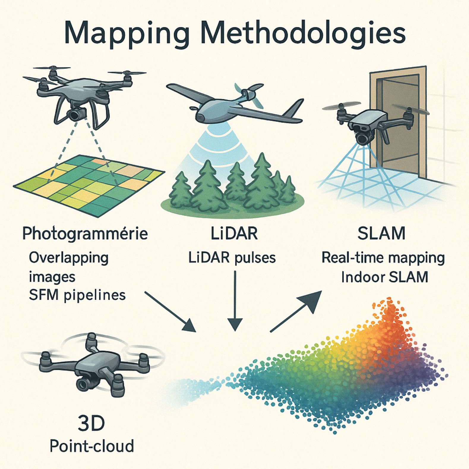
Mapping Methodologies: Photogrammetry, LiDAR & Next-Gen SLAM Engines
Mapping methodologies form the backbone of any modern drone mapping software or UAV mapping software workflow. Whether you’re creating centimetre-accurate orthomosaics for precision agriculture, fusing LiDAR scans for forestry, or deploying SLAM engines underground, understanding these core processes ensures you select the right tools and achieve reliable results every time.
1. The Photogrammetry Pipeline
At its core, photogrammetry transforms overlapping aerial images into georeferenced 2D and 3D products through a sequence of algorithmic stages:
• Structure-from-Motion (SfM)
SfM begins by detecting and matching “tie-points” across multiple images to reconstruct a sparse point cloud and estimate camera positions. When flown with appropriate overlap (70–80 %), SfM-based workflows routinely deliver ground sampling distances (GSD) of 2 cm per pixel or better, enabling horizontal accuracies within 5 cm under ideal conditions, as demonstrated by the Pix4D documentation Pix4D.
• Multi-View Stereo (MVS)
Once camera poses are established, MVS densifies the sparse cloud into a detailed point cloud. Platforms such as Agisoft Metashape and Pix4Dmapper employ optimized patch-based MVS variants to rapidly generate millions of points. Field studies report planimetric accuracies around 6 cm when processing large building façades or cultural-heritage sites data.pix4d.com.
• Bundle Adjustment
Bundled adjustment refines both camera parameters and 3D point positions by minimizing reprojection errors across all images. Many desktop drone mapping software suites now leverage GPU-accelerated solvers to cut bundle-adjustment runtimes by 30–50 %, making high-resolution projects feasible on standard workstations.
• Surface & Mosaic Generation
The final steps extract digital surface models (DSMs), digital terrain models (DTMs) and orthomosaics. Seam-line optimization and color balancing ensure the resulting maps are visually consistent and ready for GIS integration or CAD export.
2. LiDAR & Hybrid-Fusion Workflows
LiDAR mapping brings active sensing to the table, capturing direct distance measurements that penetrate vegetation and deliver unrivalled vertical accuracy:
• Pure LiDAR Surveys
Rotorcraft-mounted LiDAR sensors capture up to one million points per second at ranges exceeding 300 m, delivering vertical RMSE values under 5 cm when surveyed with proper ground checks, according to airborne LiDAR accuracy assessments ResearchGate.
• Imagery-LiDAR Fusion
Hybrid workflows merge LiDAR point clouds with photogrammetric imagery to combine the colour realism of photos with the precision of laser returns. Research on feature-level point-cloud fusion reports volumetric errors as low as 3.1 % in timber-volume estimation, illustrating the accuracy gains from intelligent data blending MDPI.
• Workflow Integration
Leading drone mapping software platforms like Bentley ContextCapture and DJI Terra Advanced natively support LiDAR import, automating registration and meshing steps so users spend less time in post-processing and more time extracting insights.
3. AI-Driven Post-Processing Enhancements
As dataset sizes grow, manual QC becomes a bottleneck. AI modules are now embedded in flagship photogrammetry suites to automate quality checks:
• Deep-Learning Denoising
Pix4Dmapper’s AI-denoiser identifies and removes image noise, shadow artifacts and moving-object streaks—cutting orthomosaic noise levels by up to 23 % and accelerating final deliverables, per the Pix4D website Pix4D.
• Automated Tie-Point Filtering
Machine-learning classifiers flag low-confidence tie-points and outliers before the bundle-adjustment stage, reducing error propagation and minimizing manual rejections, a feature increasingly common in enterprise UAV mapping software.
• Semantic Segmentation & Thematic Mapping
Some platforms integrate trained neural networks to classify land-cover types (roads, vegetation, water), enabling thematic map export directly from the processing pipeline without additional GIS post-work.
4. Real-Time & SLAM Innovations
Beyond batch photogrammetry, real-time SLAM engines are unlocking new use cases in GPS-denied and dynamic environments:
• LiDAR SLAM (Simultaneous Localization and Mapping)
Emesent’s Hovermap ST-X employs LiDAR-based SLAM to build live point-clouds in mines, tunnels and dense forest canopies. Its on-board algorithm continuously merges scans and corrects drift, enabling centimetre-scale accuracy even without GNSS, according to Emesent’s knowledge base.
• Visual SLAM & VIO
Recent surveys of visual SLAM for UAVs show that cameras fused with inertial sensors (VIO) can process at over 60 fps and maintain localization errors under 6 cm—enough for lightweight mapping drones to navigate complex structures or indoor spaces in real time.
• Edge-Compute Mapping
Next-gen drone mapping software is moving compute onto the drone itself. Emerging SCLAM (simultaneous control, localization & mapping) research promises fully autonomous BVLOS missions where the UAV plans, maps and relays results on the fly.
5. Choosing the Right Method
When evaluating drone mapping software or UAV mapping software, match your project needs to these methodologies:
- Area & Detail: Large-area surveys often benefit from LiDAR fusion for vegetation penetration, whereas small-area precision work relies on high-resolution photogrammetry.
- Environment: GPS-denied or confined spaces demand SLAM-enabled solutions like Hovermap ST-X.
- Turnaround: AI-driven pipelines cut processing times and manual QC, ideal for rapid deliverables.
- Budget & Infrastructure: Cloud-native SLAM and photogrammetry suites reduce CAPEX, while perpetual licenses and GPU clusters suit high-volume desktop workflows.
By aligning your hardware, software and algorithms with the right mapping methodology, you’ll harness the full power of drone mapping software to deliver accurate, consistent and timely geospatial products.
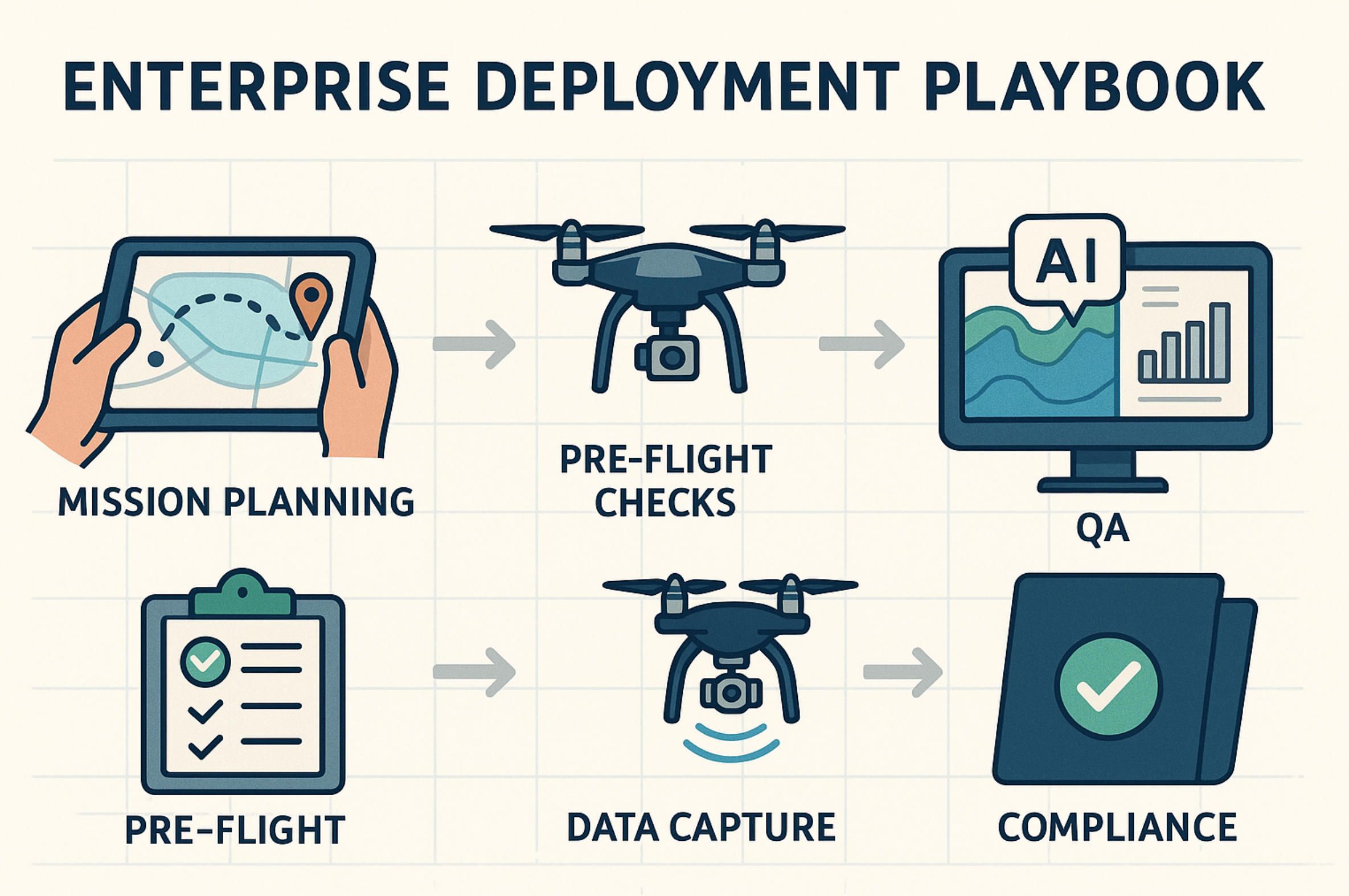
Enterprise Deployment Playbook: From Mission Planning to QA & Compliance
Deploying drone mapping software at enterprise scale requires more than just flying a UAV and letting the software churn out maps. It demands a structured playbook that guides mission planning, data capture, quality assurance (QA) and compliance reporting. Below, we outline a five-stage workflow—from pre-flight planning to regulatory sign-off—illustrating how top platforms and methods work together to ensure reliable, auditable results.
1. Strategic Mission Planning
Successful enterprise surveys start with clear objectives and robust flight plans. Teams typically use cloud-native mission-planning tools—such as DroneDeploy for dynamic waypoint design or DroneDesk for end-to-end operations management—to define survey boundaries, overlap settings (70 % front, 60 % side), altitude and sensor parameters Pilot Institute. Enterprise users often integrate Propeller Pioneer or Pix4Dfields to tailor plans for volume calculations or multispectral health indices. Flight-planning modules also automate no-fly-zone checks, weather alerts and battery-swap scheduling, reducing human error before take-off.
2. Rigorous Pre-Flight & Equipment Checks
Before each sortie, standardized pre-flight checklists ensure airworthiness and data integrity. Using DroneDesk’s built-in equipment logs, operators verify firmware versions, calibrate IMU/compass sensors and confirm RTK base-station connectivity if centimeter-level accuracy is required. Mapping teams also inspect payload mounts and lens clean-tips, then run test captures to validate image geotags. These steps, managed via operational dashboards, minimize in-field troubleshooting and support consistent datasets across multiple flights and operators.
3. Controlled Data Capture & Compliance Logging
During flight, drones equipped with RTK/PPK modules (e.g., Phantom 4 RTK or Mavic 3 Enterprise RTK) record precise location metadata, slashing the need for ground control points by up to 80% Dronedesk blog. Concurrently, compliance platforms like DroneDesk automate flight-log archiving, waiver tracking and geofence enforcement—essential for audits and insurance. Teams export standardized CSV logs and flight-path overlays directly from DroneDesk or Dronedesk.io, creating a tamper-evident record that satisfies regulators and clients alike.
4. Automated QA & Validation
Post-flight, QA processes catch anomalies before deliverables are released. Leading UAV mapping software embeds validation checks—Coptrz’s criteria, for instance, recommend built-in geometric accuracy reports, tie-point consistency metrics and comparison against GCPs to flag outliers Coptrz. Pix4Dmapper’s project report generates RMSE and reprojection-error statistics, while DroneDeploy’s Copilot™ AI layer highlights low-confidence mesh regions. Propeller Pioneer’s Autogrid™ PPK validation further verifies baseline integrity, ensuring point-cloud consistency across adjacent grids.
5. Compliance Reporting & Regulatory Sign-Off
Enterprises must demonstrate data provenance, safety adherence and environmental compliance. Platforms like Dronedesk.io consolidate pilot certifications, maintenance logs and risk assessments into unified compliance reports, complete with date-stamped screenshots of airspace authorizations and waiver approvals Dronedesk blog. These consolidated deliverables—often exported as PDF archives—form the compliance dossiers submitted to bodies such as FAA, EASA or local authorities. Having a repeatable, software-driven process accelerates approvals for BVLOS operations and large-scale projects.
6. Secure Data Governance & Archival
After map delivery, enterprises need robust data governance. A Bots.com recommends storing raw imagery, processing projects and compliance logs in enterprise cloud vaults with SOC 2 or ISO 27001 certification, ensuring long-term accessibility and audit readiness. Role-based access controls prevent unauthorized edits, while automated retention policies archive older projects to cold storage—optimizing costs without sacrificing traceability.
7. Continuous Improvement & Analytics
Finally, analytics dashboards track mission KPIs—such as average RTK fix time, processing durations and QA-flag rates—enabling teams to refine flight-planning settings and software configurations. By monitoring Copilot™ QA pass rates or Propeller Pioneer’s volume-report accuracy over time, operations managers can iterate on sensor configurations and overlap parameters, driving down reflight costs and boosting overall mapping throughput.
By weaving together mission-planning apps, precise RTK/PPK capture, automated QA modules and compliance platforms, enterprises can roll out drone mapping software at scale—delivering survey-grade maps with auditable, defensible workflows. This playbook not only streamlines operations, but also underpins the trust and accountability that large clients and regulators demand.
✅ Hashtags
#DroneMappingSoftware
#UAVMappingSoftware
#AerialSurvey
#Photogrammetry
#LiDAR
#SLAM
#EnterpriseUAV
Other articles
App for DJI Drone: Custom Flight Control and Mapping Solutions DJI dominates the skies, yet real value materialises only when flight data flows into business-ready insights. Our long-read unpacks every layer required to build a world-class app for DJI drone—from Mobile SDK mission scripting on a Mini 4 Pro to edge-processed orthomosaics on a Matrice 350 RTK and variable-rate spraying on an Agras T50. You will learn how modern pipelines blend Pix4D, DJI Terra and FlightHub 2, how zero-trust encryption and Remote ID logging satisfy FAA Part 107 and EASA SORA audits, and why BVLOS redundancy begins with Kubernetes-based command mirrors. Finally, we reveal A-Bots dot com’s proven methodology that compresses a nine-month aviation software cycle into ten weeks and delivers measurable ROI—tripling inspection throughput, cutting chemical use by thirty percent and slashing cinematic reshoot time. Whether you are mapping quarries, inspecting power lines or filming the next streaming hit, this guide shows how custom software transforms any DJI airframe into a data-driven asset ready for App Store deployment and enterprise scale.
Drone Mapping Software (UAV Mapping Software): 2025 Guide This in-depth article walks through the full enterprise deployment playbook for drone mapping software or UAV mapping software in 2025. Learn how to leverage cloud-native mission-planning tools, RTK/PPK data capture, AI-driven QA modules and robust compliance reporting to deliver survey-grade orthomosaics, 3D models and LiDAR-fusion outputs. Perfect for operations managers, survey professionals and GIS teams aiming to standardize workflows, minimize field time and meet regulatory requirements.
Custom Drone Software Mastery - ArduPilot and MissionPlanner This long-read unpacks the commercial drone boom, then dives into the technical backbone of ArduPilot and Mission Planner—one open, multi-domain codebase and a ground station that doubles as a full-stack lab. From rapid-prototype firmware to data-driven optimisation retainers, A-Bots.com shows how disciplined codecraft delivers measurable wins: 40 % fewer mission aborts, 70% faster surveys, and faster BVLOS approvals. Finally, the article looks ahead to AI-augmented navigation, Kubernetes-coordinated swarms and satellite-linked control channels, detailing the partnerships and R&D milestones that will shape autonomous, multi-domain operations through 2034. Read on to see why enterprises choose A-Bots.com to turn ambitious flight plans into certified, revenue-earning reality.
Offline AI Agent for Everyone A-Bots.com is about to unplug AI from the cloud. Our upcoming solar-ready mini-computer runs large language and vision models entirely on device, pairs with any phone over Wi-Fi, and survives on a power bank. Pre-orders open soon—edge intelligence has never been this independent.
Custom Agriculture App Development for Farmers In 2024, U.S. farmers are more connected than ever — with 82% using smartphones and 85% having internet access. This article explores how mobile applications are transforming everyday operations, from drone-guided field scouting to livestock health tracking and predictive equipment maintenance. It examines why off-the-shelf apps often fail to address specific farm needs and how collaborative, farmer-funded app development is gaining momentum. Through real-world examples and step-by-step guidance, readers will learn how communities of growers can fund, design, and launch custom apps that fit their exact workflows. A-Bots.com offers tailored development services that support both solo farmers and agricultural groups. With offline capabilities, modular design, and support for U.S. and international compliance, these apps grow alongside the farm. Whether you're planting soybeans in Iowa, raising cattle in Texas, or running a greenhouse in California — this article offers the tools and inspiration to build your own farm technology. Discover why more farmers are saying: we don’t wait for the future — we build it.
Custom Drone Mapping Software & Control Apps: Smarter Aerial Solutions by A-Bots.com Custom drone software is revolutionizing how industries operate—from precision agriculture to infrastructure inspection. This article explores why off-the-shelf apps fall short, how AI and modular design shape the future, and how A-Bots.com delivers tailored drone solutions that truly fit. Whether you manage crops, assets, or entire projects, the right software lifts your mission higher.
Top stories
Copyright © Alpha Systems LTD All rights reserved.
Made with ❤️ by A-BOTS