Home
Services
About us
Blog
Contacts
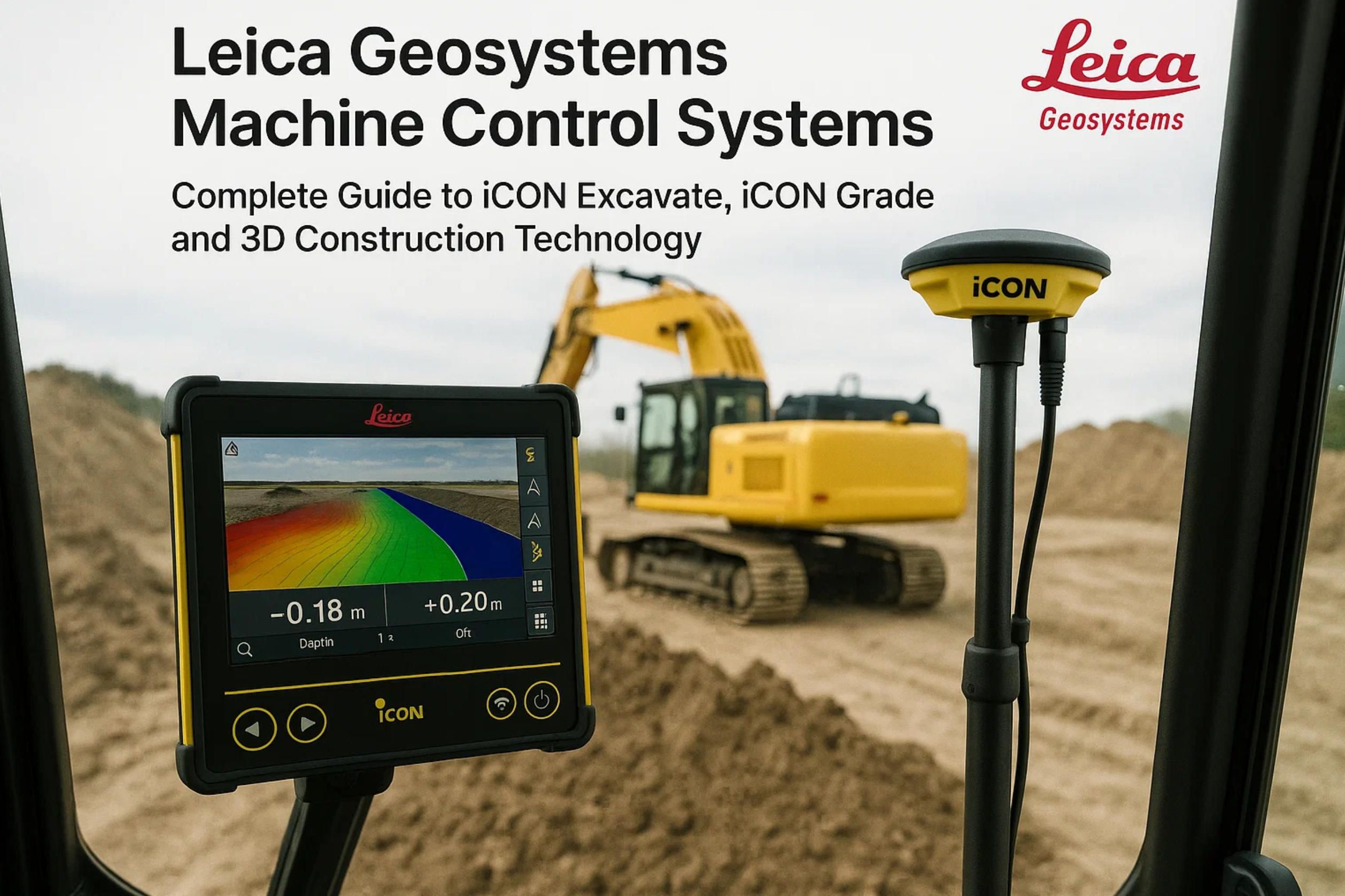
Leica Geosystems Machine Control Systems: Complete Guide to iCON Excavate, iCON Grade and 3D Construction Technology
Developing advanced ground control solutions for Leica Geosystems construction technology? A-Bots.com mobile app development company specializes in custom software development for Leica Geosystems machine control systems and construction ground control station technologies. Whether you need custom mobile applications integrating with Leica iCON site management platforms, API development connecting Leica Geosystems displays to enterprise construction management systems, automated workflow solutions for as-built data processing, 3D visualization dashboards for real-time earthmoving operations monitoring, or comprehensive testing and validation of Leica iCON excavate and Leica iCON grade compatibility across diverse equipment configurations, our development team delivers production-ready solutions. We create tailored ground control interfaces for remote equipment monitoring, develop custom design file conversion tools optimizing CAD/BIM integration with Leica Geosystems platforms, build cloud synchronization layers for Leica ConX data management, implement advanced analytics transforming machine control data into actionable project insights, and provide quality assurance testing ensuring flawless system performance. From independent contractors to construction technology companies and heavy equipment dealers, A-Bots.com enhances Leica Geosystems implementations through expert software development addressing your unique operational requirements and maximizing construction technology investments.
Leica Geosystems: Precision Measurement Heritage in Construction Technology
Leica Geosystems established its position as a precision measurement technology leader through over 200 years of Swiss engineering excellence, tracing origins to 1819 when the company began manufacturing optical instruments. The organization evolved through theodolite production, survey equipment innovation, and photogrammetry systems before entering construction machine control markets in the 1990s. This extensive measurement technology heritage provides Leica Geosystems with deep expertise in positioning accuracy, sensor integration, and precision control systems that construction applications demand.
Hexagon AB acquired Leica Geosystems in 2005, integrating the company into Hexagon's broader measurement technology portfolio. This acquisition provided substantial resources accelerating construction technology development while maintaining Leica Geosystems brand identity and Swiss engineering culture. The Hexagon relationship enables cross-pollination between surveying, industrial metrology, and construction machine control divisions, creating technology synergies benefiting all product lines.
Leica Geosystems holds approximately 25-30% of the global construction machine control market, positioning as the second-largest provider behind Trimble but ahead of Topcon and manufacturer-specific solutions. The company maintains particularly strong market positions in European construction markets where Leica Geosystems brand recognition and local support infrastructure provide competitive advantages. German, Swiss, Austrian, and Scandinavian contractors demonstrate high Leica Geosystems adoption rates appreciating the brand's precision engineering heritage and quality reputation.
The Leica Geosystems construction technology ecosystem encompasses multiple integrated components: Leica iCON excavate systems providing 3D machine control for excavators, Leica iCON grade delivering automated blade control for dozers and graders, Leica iCON site office software managing design files and project data, ground control station displays presenting real-time operational information to equipment operators, and comprehensive GNSS receivers and sensor systems providing positioning data across accuracy tiers.
Leica iCON Excavate: 3D Machine Control for Excavators
Leica iCON excavate represents Leica Geosystems' flagship excavator machine control system, providing real-time 3D guidance enabling operators to dig precisely to design elevations without constant grade checking or surveyor assistance. The system transforms traditional excavator operation from experience-based estimation to precision digital guidance, dramatically improving productivity and accuracy.
System Architecture and Components
3D Positioning Technology:
Leica iCON excavate utilizes multiple positioning technologies creating comprehensive 3D awareness of excavator bucket position relative to design surfaces. The system combines GNSS receivers tracking satellite constellations, inertial measurement units (IMU) measuring boom, stick, and bucket angles, and advanced sensor fusion algorithms calculating precise bucket cutting edge position in three-dimensional space.
The multi-sensor approach provides robust positioning across diverse site conditions. GNSS delivers absolute position referenced to project coordinate systems, while IMUs provide relative positioning unaffected by satellite visibility or multipath interference. The sensor fusion operates at 20 Hz update rates, delivering smooth real-time bucket position tracking without lag or delay. This high-frequency operation enables operators to observe bucket movement continuously during digging cycles, maintaining awareness of proximity to design grades throughout operations.
Leica iCON Excavate Components:
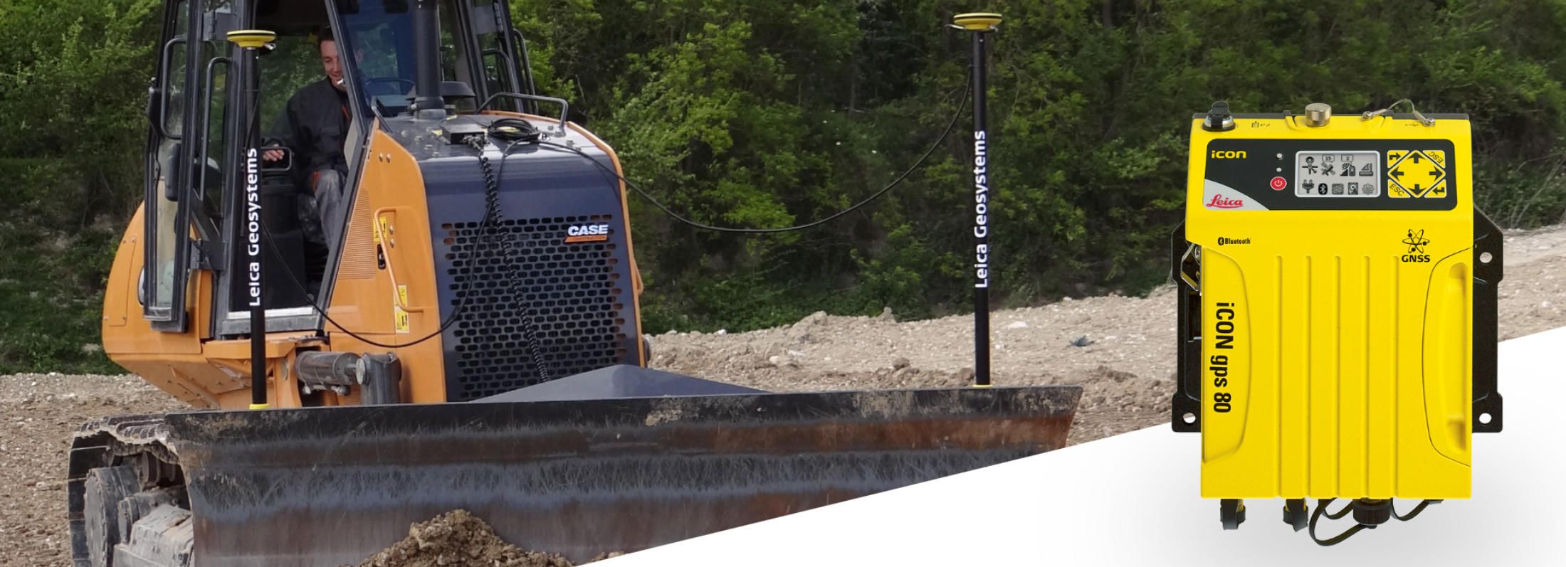
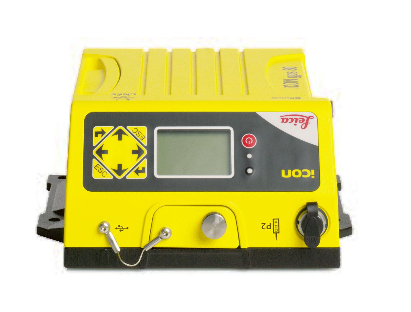
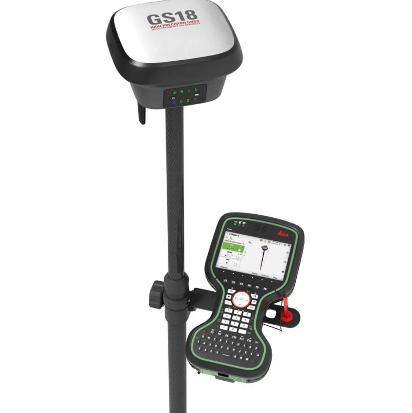
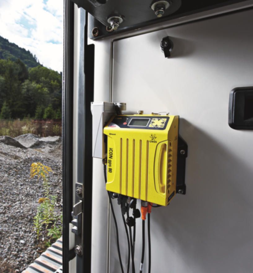
iCG80 GNSS Receiver - Dual-frequency multi-constellation GNSS receiver mounted on excavator cab providing absolute positioning reference. The receiver tracks GPS, GLONASS, Galileo, and BeiDou satellites simultaneously, maximizing satellite availability and positioning reliability across global regions.
Technical Specifications:
- Satellite Systems: GPS L1/L2/L5, GLONASS L1/L2, Galileo E1/E5a/E5b, BeiDou B1/B2/B3
- Channels: 555+ simultaneous tracking
- Update Rate: 20 Hz position output
- Correction Support: RTK, RTCM 3.x, SmartLink corrections
- Accuracy: 8 mm + 1 ppm horizontal, 15 mm + 1 ppm vertical with RTK
- Initialization Time: <10 seconds with RTK
- Operating Temperature: -40°C to +65°C
- Power: 9-32 VDC, 8W typical
- Dimensions: 178 mm diameter x 125 mm height
- Weight: 1.9 kg
- Ingress Protection: IP68/IP69K (submersion resistant, high-pressure washdown)
iAS10 Angle Sensors - High-precision rotary encoders measuring boom, stick, and bucket angles with 0.01-degree resolution. The sensors mount at excavator pivot points using robust mechanical connections withstanding heavy equipment vibration and shock loads.
Technical Specifications:
- Measurement Range: 360 degrees continuous rotation
- Resolution: 0.01 degrees (36,000 counts per revolution)
- Accuracy: ±0.05 degrees
- Update Rate: 50 Hz
- Operating Temperature: -40°C to +85°C
- Shock Resistance: 100g
- Vibration Resistance: 15 Grms continuous
- Ingress Protection: IP67
- Connection: CANbus digital output
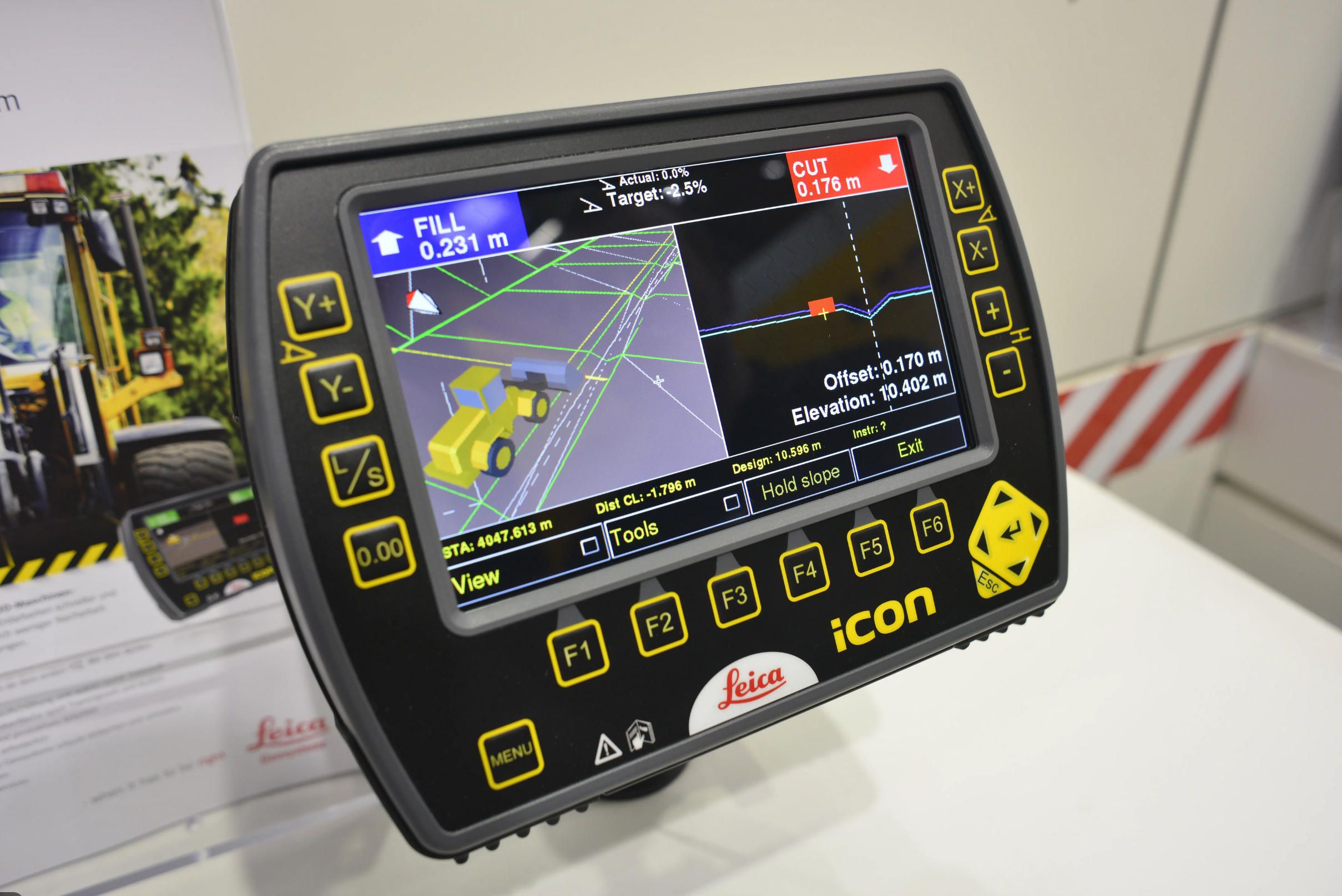
iCP50 Machine Control Panel - Operator interface display presenting 3D design information, bucket position, cut/fill indicators, and system status. The rugged touchscreen display mounts in excavator cab within operator's natural sight line.
Technical Specifications:
- Screen Size: 12.1 inches diagonal
- Resolution: 1280 x 800 pixels (WXGA)
- Display Technology: LED backlit LCD with anti-glare treatment
- Brightness: 1000 nits with automatic ambient adjustment
- Touchscreen: Resistive multi-touch, glove-compatible
- Processor: Quad-core ARM Cortex-A9 at 1.6 GHz
- Memory: 4 GB RAM, 32 GB storage
- Operating Temperature: -30°C to +70°C
- Storage Temperature: -40°C to +85°C
- Ingress Protection: IP65
- Power: 10-32 VDC, 25W maximum
- Dimensions: 320 mm x 220 mm x 50 mm
- Weight: 1.6 kg
Tilt Sensor - Precision dual-axis inclinometer measuring excavator body tilt compensating for machine positioning on slopes. The sensor enables accurate bucket position calculation even when excavators operate on angled terrain.
Technical Specifications:
- Measurement Range: ±30 degrees both axes
- Resolution: 0.01 degrees
- Accuracy: ±0.1 degrees
- Update Rate: 20 Hz
- Operating Temperature: -40°C to +75°C
- Ingress Protection: IP67
Leica iCON Excavate Operational Capabilities
Real-Time 3D Guidance:
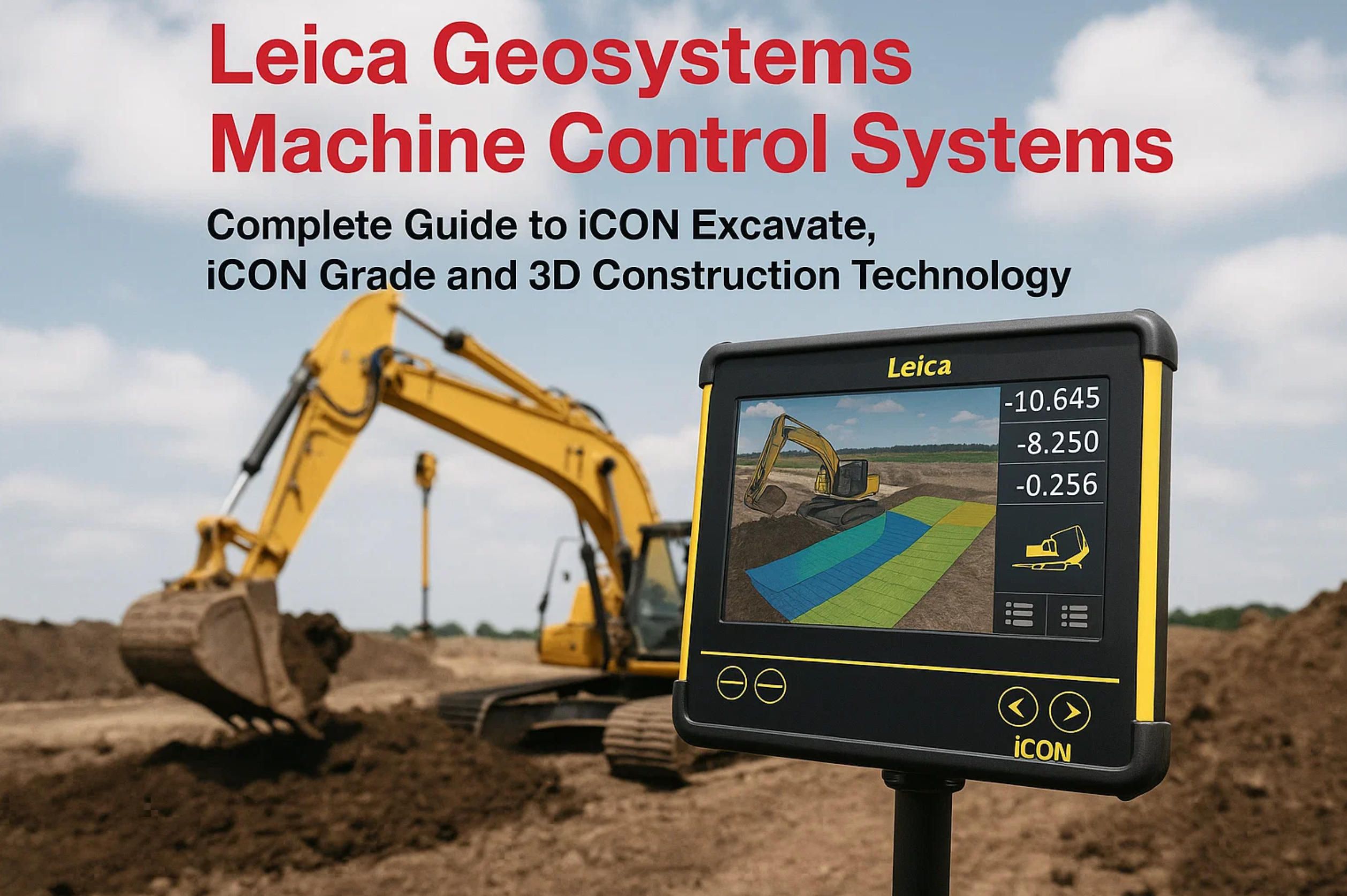
The system continuously calculates bucket cutting edge position in three dimensions, comparing actual position against loaded 3D design surfaces. The iCP50 display presents this information through multiple visualization modes optimized for different operational contexts.
2D Cross-Section View - Displays vertical slice through design showing current bucket position relative to design grade. This view excels for depth control when digging trenches, foundations, or other linear excavations. Operators observe bucket position approaching design grade, receiving visual and audible alerts when reaching target depths.
3D Perspective View - Presents three-dimensional representation of design surface with excavator and bucket position overlaid. This visualization enables operators to understand spatial relationships between current position and surrounding design elements including slopes, benches, and adjacent features. The 3D view particularly benefits complex grading operations where understanding overall surface context improves operational efficiency.
Plan View - Shows top-down perspective displaying excavator position on site plan with design elements overlaid. This view assists navigating to work areas, understanding excavation boundaries, and coordinating with other equipment operating on site.
Guidance Indicators:
Color-coded cut/fill indicators show whether bucket position is above grade (cut required), on grade (correct elevation), or below grade (fill required). The color progression from red (significant cut) through yellow (approaching grade) to green (on grade) provides intuitive feedback operators understand immediately without interpreting numeric values.
Numeric displays show exact distance from bucket cutting edge to design surface with millimeter precision. When bucket sits 127 mm above design grade, the display shows "+127 mm" with red coloring indicating cut requirement. As operators dig approaching design, the numeric value decreases and color shifts toward green, providing precise feedback supporting accurate grade achievement.
Audio alerts supplement visual indicators, providing feedback operators perceive without constant display monitoring. Distinct tones indicate approaching grade (200 mm proximity), reaching grade (within ±50 mm), and digging below grade (overcutting). The audible feedback enables operators to focus on bucket control and material loading while maintaining grade awareness through sound cues.
Installation and Calibration
Excavator Installation:
Leica iCON excavate installation requires mounting sensors at specific locations measuring excavator geometry. The iCG80 GNSS receiver mounts on cab roof with unobstructed sky view. Angle sensors install at boom, stick, and bucket pivot points using custom brackets matched to specific excavator models. The tilt sensor mounts on excavator body in protected location away from engine heat and vibration sources.
Installation typically requires 6-10 hours depending on excavator model and installer experience. Leica Geosystems provides model-specific installation kits containing pre-engineered mounting brackets, custom wiring harnesses with weatherproof connectors, and detailed installation instructions. Experienced installers complete installations efficiently following documented procedures, though first-time installations on unfamiliar equipment models may require additional time for fitment verification and adjustment.
System Calibration:
Calibration procedures establish the mathematical relationship between sensor measurements and physical excavator dimensions. The process measures boom length, stick length, bucket dimensions, and sensor mounting positions, storing these parameters in system configuration files.
Calibration begins with excavator positioned on level ground with boom, stick, and bucket extended in known configuration. Operators measure physical dimensions between pivot points using tape measures or laser distance meters, entering measurements into the iCP50 display through calibration menus. The system then guides operators through bucket movement sequences, measuring sensor outputs across excavator's full range of motion and validating that measured angles correspond correctly to physical geometry.
Advanced calibration procedures utilize robotic total stations automatically measuring bucket position throughout movement sequences. The total station provides independent position verification with millimeter accuracy, allowing the system to optimize calibration parameters achieving maximum accuracy. This automated calibration proves particularly valuable for complex excavator configurations or when targeting highest accuracy specifications.
Typical calibration requires 30-45 minutes for manual procedures or 15-20 minutes with robotic total station assistance. Well-calibrated systems achieve bucket position accuracy within ±20 mm across full excavator working envelope, sufficient for most construction applications. Critical applications demanding higher accuracy may utilize enhanced calibration procedures achieving ±10 mm performance.
Performance Characteristics
Positioning Accuracy:
Leica iCON excavate achieves positioning accuracy specifications dependent on correction service employed and site conditions:
RTK Corrections - Real-time kinematic satellite corrections deliver highest accuracy at ±15 mm vertical, ±20 mm horizontal for bucket position. This accuracy level suits virtually all construction applications including precise foundation excavation, utility trenching to exact depths, and complex grading operations.
Network RTK - Regional correction networks broadcasting via cellular connections provide similar accuracy to base station RTK with ±15-20 mm vertical performance. Network RTK eliminates base station ownership and maintenance requirements while delivering equivalent positioning performance across network coverage areas.
SmartLink Corrections - Leica Geosystems' satellite-delivered corrections provide ±40 mm vertical accuracy without base stations or network subscriptions. This accuracy suffices for many bulk earthmoving operations where centimeter-level precision isn't required. SmartLink delivers global coverage enabling consistent performance across project locations worldwide.
System Reliability:
Field testing demonstrates Leica iCON excavate maintains consistent performance across demanding construction environments. The IP68/IP69K rated components withstand complete water submersion, high-pressure washdown, mud, dust, and chemical exposure common on construction sites. Angle sensors function reliably through -40°C to +85°C temperature ranges encompassing arctic and desert construction conditions.
The system architecture implements redundancy ensuring continued operation despite individual sensor failures. If GNSS signals become blocked by buildings or terrain, the system continues operating using angle sensors and last-known position, alerting operators about reduced accuracy but maintaining basic functionality. This graceful degradation prevents complete system failures disrupting operations.

Leica iCON Grade: Automated Blade Control Systems
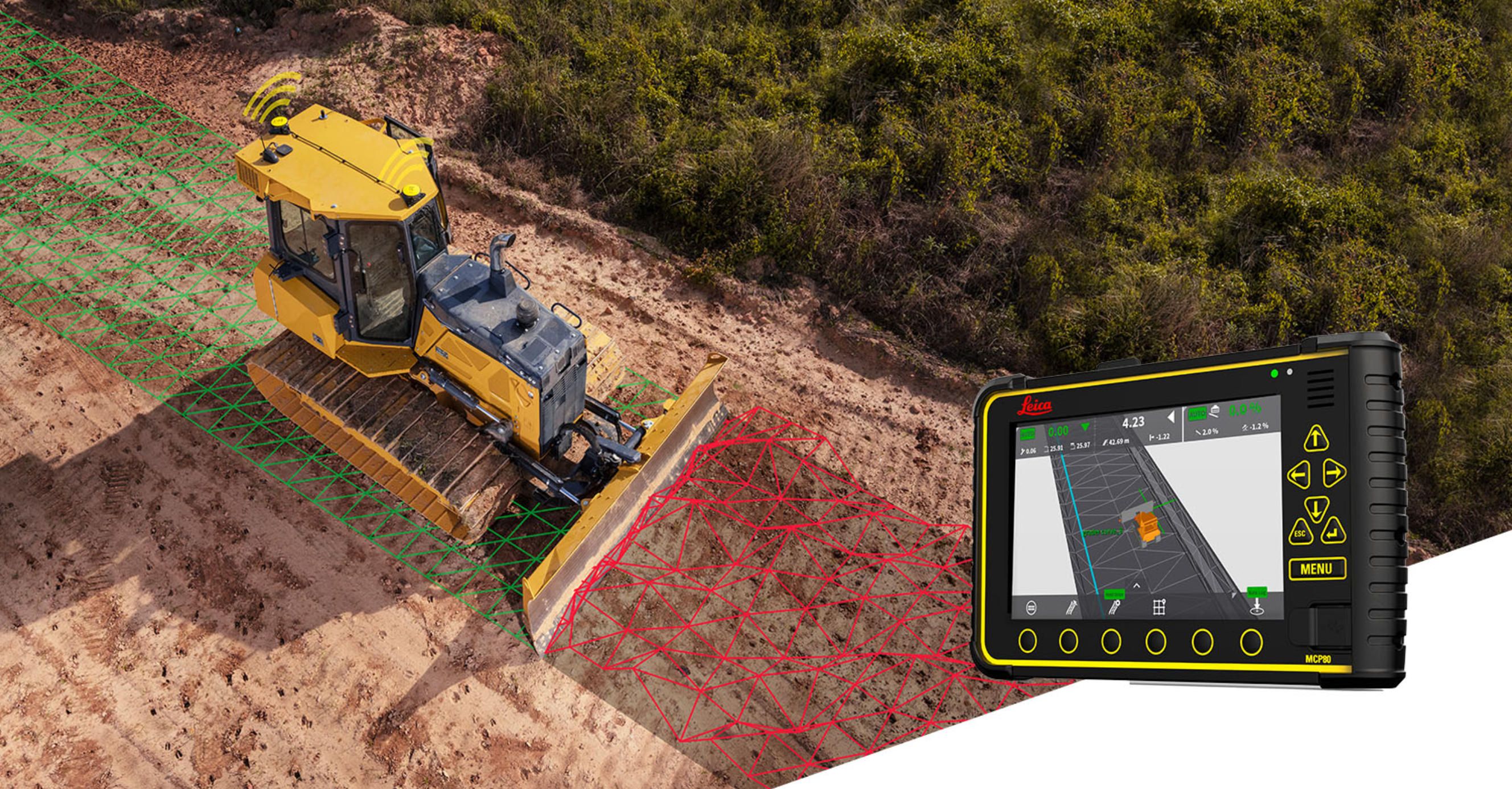
Leica iCON grade delivers automated blade control for dozers and motor graders, continuously adjusting blade elevation maintaining design grades without constant operator input. The system transforms blade operation from manual control requiring continuous attention to automated precision guidance enabling operators to focus on forward progress and material management.
System Components and Architecture
Leica iCON Grade System Elements:
iGG4 Plus GNSS Receivers - Dual GNSS receivers mounted on blade corners providing redundant positioning and blade tilt measurement. The dual-receiver configuration measures both blade position and cross-slope simultaneously, enabling full 3D blade control.
Technical Specifications (per receiver):
- Satellite Systems: GPS L1/L2, GLONASS L1/L2, Galileo E1/E5a, BeiDou B1/B2
- Channels: 440+ simultaneous
- Update Rate: 20 Hz
- Accuracy: ±10 mm + 1 ppm horizontal, ±20 mm + 1 ppm vertical with RTK
- Operating Temperature: -40°C to +65°C
- Power: 9-36 VDC, 7W typical
- Ingress Protection: IP68/IP69K
- Weight: 1.6 kg each
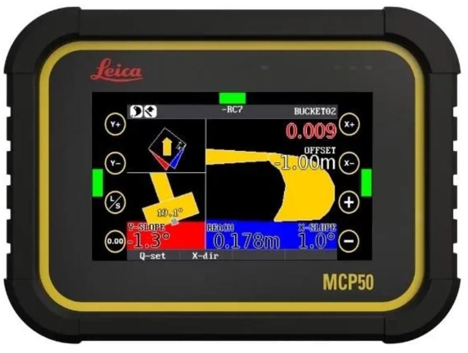
iGD4 Grade Control Display - Operator interface presenting design information, blade position, cut/fill guidance, and automated control status. The display mounts in equipment cab providing clear visibility without obstructing operator sight lines.
Technical Specifications:
- Screen Size: 10.4 inches diagonal
- Resolution: 1024 x 768 pixels (XGA)
- Brightness: 1200 nits
- Touchscreen: Capacitive multi-touch
- Processor: Quad-core ARM Cortex-A53 at 1.4 GHz
- Operating Temperature: -30°C to +70°C
- Ingress Protection: IP66
- Power: 10-32 VDC, 18W maximum
Valve Controllers - Proportional hydraulic valve controllers automatically adjusting blade lift cylinders maintaining design elevations. The controllers integrate with equipment hydraulic systems, modulating cylinder extension and retraction with millimeter-level precision.
Technical Specifications:
- Control Outputs: Dual proportional PWM (blade lift, blade tilt)
- Response Time: <50 milliseconds
- Control Resolution: 0.1 mm blade movement
- Operating Temperature: -40°C to +85°C
- Ingress Protection: IP67
Machine Sensors - Additional sensors including tilt compensators, sonic trackers (for laser systems), and machine-specific position sensors providing comprehensive awareness of equipment orientation and blade configuration.
Automated Control Modes
Full Automatic Mode:
In full automatic mode, Leica iCON grade continuously adjusts blade elevation maintaining design grade as equipment travels across sites. Operators control forward speed and steering while the system manages blade height automatically. This automation dramatically reduces operator workload, enabling focus on production rather than constant blade control adjustments.
The system implements sophisticated control algorithms accounting for equipment characteristics, ground conditions, and operational parameters. When traveling uphill, the system anticipates blade position changes from equipment pitch, adjusting proactively rather than reactively. On cross-slopes, the control compensates for equipment roll maintaining level blade position despite machine tilt.
Operators configure control parameters including maximum blade movement speed, control aggressiveness, and elevation tolerances. Conservative settings produce smooth gradual blade adjustments suitable for finish grading, while aggressive settings enable rapid response appropriate for rough grading operations. The configurable control accommodates diverse operational requirements and operator preferences.
Semi-Automatic Mode:
Semi-automatic mode provides automated elevation control for one blade edge while operators manually control the opposite edge. This mode suits situations where one blade side follows existing terrain or construction features while the opposite side cuts to design grade. Motor graders often operate in semi-automatic mode when establishing road cross-slopes or ditch profiles.
Manual Guidance Mode:
Manual mode disables automated control, presenting only visual guidance information. Operators control blade position manually while receiving real-time cut/fill indicators showing deviation from design grade. This mode proves useful when operating in confined areas requiring careful manual control, when training new operators on system functionality, or when automated control malfunctions requiring manual operation.
Design Loading and Management
3D Design File Support:
Leica iCON grade accepts industry-standard 3D design file formats including LandXML, DXF, and proprietary formats from major civil engineering software. The system interprets these files extracting design surfaces, alignments, and elevation data required for automated control. Design files load directly to displays via USB drives, Bluetooth file transfer, or wireless synchronization through Leica ConX cloud platform.
Complex designs containing multiple surfaces, construction phases, and element types are managed through the display's design library. Operators select appropriate design surfaces for current operations, switching between designs as work progresses. The system tracks which designs were utilized when, supporting as-built documentation and quality verification.
Design Verification and Visualization:
Before commencing automated grading, operators verify design file correctness through visualization tools. The display presents design surfaces in 3D perspective views, cross-sections, and plan layouts enabling operators to confirm that loaded designs match project plans and expectations. This verification prevents costly mistakes from incorrect design files or coordinate system mismatches.
The visualization tools enable operators to preview upcoming grade transitions, identify challenging areas requiring attention, and plan optimal equipment paths. Understanding design intent before beginning operations improves efficiency and reduces errors from unexpected design elements discovered during grading.
Leica iCON Site: Office Software and Project Management
Leica iCON site serves as the office software component managing design files, project data, equipment configurations, and operational documentation. The Windows-based application provides tools for design preparation, data management, and coordination between office staff and field operators.
Design Preparation and Conversion
CAD File Import:
Leica iCON site imports 3D models from major civil engineering software including AutoCAD Civil 3D, Bentley MicroStation, Trimble Business Center, and generic formats like LandXML and DXF. The import process converts engineering designs into machine-readable formats optimized for field display and automated control.
During import, the software validates design integrity checking for gaps, overlaps, or inconsistencies in surface definitions. Design errors identified during import are flagged for correction, preventing problematic files from transferring to field equipment where issues would disrupt operations. This quality verification ensures designs meet machine control requirements before field deployment.
Design Simplification:
Complex engineering models often contain excessive detail unnecessary for machine control. Leica iCON site includes tools simplifying designs while preserving essential geometric accuracy. The simplification reduces file sizes enabling faster data transfer and improving display performance on field equipment with limited processing resources.
Simplification algorithms identify and remove redundant triangulation, combine adjacent planar surfaces, and eliminate non-essential design elements. The process maintains surface accuracy within specified tolerances (typically ±10 mm) while reducing file complexity by 50-80%. Smaller optimized files load faster, render smoothly on displays, and consume less storage memory.
Coordinate System Management:
Construction projects utilize diverse coordinate systems including local site grids, state plane coordinates, UTM zones, and project-specific systems. Leica iCON site manages coordinate transformations ensuring design files, GNSS positioning, and survey data align correctly in common reference frames.
The software supports hundreds of predefined coordinate systems covering global regions plus custom system definitions for project-specific requirements. Transformation parameters including scale factors, rotation angles, and datum shifts are configured ensuring millimeter-level accuracy across coordinate conversions. Proper coordinate management prevents positioning errors that would cause equipment to grade incorrect locations despite accurate GNSS positions.
Data Synchronization and Management
Leica ConX Cloud Platform Integration:
Leica iCON site integrates with Leica ConX, the cloud-based data management platform connecting office software with field equipment. Design files uploaded to ConX automatically synchronize to connected machines when cellular or Wi-Fi connectivity exists. This wireless workflow eliminates USB drive handling and ensures field equipment always accesses current design revisions.
As-built data from field equipment uploads to ConX continuously during operations, providing office staff with near-real-time visibility into construction progress. Managers review completed work, identify areas requiring attention, and coordinate resources based on actual field conditions rather than scheduled assumptions.
Project Organization:
Leica iCON site organizes information hierarchically by project, allowing management of multiple simultaneous jobs. Each project contains associated design files, equipment configurations, correction service settings, and operational data. This structure prevents cross-contamination between projects and simplifies data retrieval when projects span months or years.
Within projects, data organizes by construction phase, equipment type, and operator enabling detailed tracking and analysis. Managers generate reports showing productivity by crew, material quantities moved per shift, or grade accuracy statistics supporting quality documentation and process improvement initiatives.
Quality Control and Verification
As-Built Comparison:
Leica iCON site compares as-built measurements from field operations against original designs, generating deviation reports quantifying construction quality. The analysis identifies areas where actual construction deviated from plans, supporting quality verification and payment calculations.
Deviation reports present information through multiple formats including color-coded surface maps showing elevation differences, statistical summaries of mean error and standard deviation, and tabular data for specific locations. These reports satisfy quality documentation requirements for contracts specifying construction tolerances and accuracy standards.
Volume Calculations:
The software calculates earthwork volumes comparing design surfaces against existing ground or as-built surfaces. Volume reports support payment verification, material tracking, and project cost management. The calculations utilize precise triangulated surface models ensuring accuracy meeting engineering standards and contract requirements.
Volume calculation methods include:
Cut/Fill Volumes - Calculates material requiring excavation (cut) or placement (fill) comparing design surface against existing terrain. The analysis identifies net cut, net fill, and areas requiring material import or disposal. Project managers utilize volume calculations for bidding, material procurement, and haul distance optimization.
Progress Volumes - Tracks cumulative material moved throughout project duration, comparing as-built surfaces at different dates. Progress tracking supports payment applications tied to quantity completion, identifies productivity trends, and forecasts project completion timelines based on historical production rates.
Stockpile Volumes - Measures material quantities in storage piles using as-built surface measurements. Accurate stockpile volumes support inventory management, prevent material shortages or excess, and verify material deliveries against supplier invoices.
The volume calculation engine accounts for swell and shrinkage factors converting between in-place volumes, loose volumes, and compacted volumes. These factors vary by material type - clay, sand, gravel, rock - and significantly impact material quantities. Proper factor application ensures volume calculations reflect actual material movements rather than theoretical geometric volumes.
Positioning and Correction Services
Leica Geosystems supports multiple positioning methodologies and correction services enabling operations to select solutions matching accuracy requirements and budget constraints.
GNSS Positioning Technologies
RTK Base and Rover:
Traditional RTK positioning utilizes a base station at known coordinates broadcasting correction data to field rovers via radio link. The base station measures satellite signal errors at its location, transmitting corrections enabling rovers to achieve centimeter-level accuracy within radio range (typically 5-10 km depending on terrain and radio power).
Leica Geosystems offers multiple base station solutions:
GS18 I Base Station - Premium GNSS base station providing highest accuracy RTK corrections. The unit operates autonomously after initial setup, requiring no operator intervention during operations.
Technical Specifications:
- Satellite Systems: GPS, GLONASS, Galileo, BeiDou, QZSS (555+ channels)
- Base Station Accuracy: 3 mm + 0.1 ppm horizontal, 3.5 mm + 0.4 ppm vertical
- Radio Options: Internal UHF 410-470 MHz, 1W/2W/4W power
- Range: 3-10 km depending on power and terrain
- Battery Life: 7+ hours continuous operation
- Operating Temperature: -40°C to +65°C
- Ingress Protection: IP68
- Weight: 1.05 kg
Base station ownership costs $12,000-$18,000 for hardware plus ongoing maintenance including radio licensing fees, cellular connectivity for remote monitoring, and periodic calibration verification. The investment suits projects with long duration (6+ months), remote locations without network RTK coverage, or operations requiring guaranteed correction availability independent of third-party services.
Network RTK:
Network RTK services utilize permanent base station networks operated by commercial providers or government agencies. The networks broadcast corrections via cellular internet connections (NTRIP protocol), eliminating base station ownership and maintenance requirements. Field equipment requires only cellular connectivity to access correction streams.
Network RTK provides several advantages over base station systems including larger coverage areas (statewide or regional), no radio range limitations, and elimination of base setup time and complexity. The service model suits mobile operations moving between sites, short-duration projects where base station costs don't amortize effectively, or contractors wanting predictable subscription costs rather than capital equipment investments.
Network RTK subscription costs vary by provider and region, typically ranging $1,200-$2,500 per rover annually. Many providers offer monthly subscriptions ($150-$300) accommodating seasonal operations or short-term projects. Coverage quality varies significantly between regions - urban areas generally have excellent network coverage while remote rural locations may have limited or no network availability.
SmartLink Satellite Corrections
Leica SmartLink Technology:
SmartLink delivers satellite-based GNSS corrections enabling 30-40 mm accuracy without base stations or network subscriptions. The service broadcasts corrections via geostationary communication satellites, providing global coverage including remote areas without cellular connectivity.
SmartLink corrections require 5-15 minutes convergence time after initial receiver startup to achieve full accuracy. During convergence, accuracy gradually improves from meter-level to final 30-40 mm performance. This convergence delay requires planning - operators should power systems on during site mobilization, allowing convergence completion before beginning grading operations.
The technology suits applications where 30-40 mm accuracy suffices, including rough grading, site preparation, road sub-base construction, and bulk earthmoving. Operations requiring higher precision for finish grading or critical infrastructure utilize RTK corrections, while SmartLink handles less demanding phases reducing RTK subscription costs.
SmartLink annual subscriptions cost $1,800-$2,400 per receiver, positioning between free basic GNSS (meter-level accuracy) and premium RTK services. The global coverage and elimination of base station complexity create value for international contractors, remote project locations, or operations wanting simplified technology deployments.
Laser and Optical Positioning
Rotating Laser Systems:
In confined construction sites where GNSS signals are obstructed by buildings, bridges, or tunnels, Leica Geosystems integrates rotating laser systems providing optical positioning. A rotating laser establishes a reference plane, while machine-mounted laser receivers detect the beam determining equipment position relative to the reference plane.
Leica Rugby Series Lasers:
Technical Specifications:
- Beam Range: 600-800 meters radius depending on model and conditions
- Accuracy: ±1.5 mm at 100 meters
- Rotation Speed: 600 RPM
- Self-Leveling Range: ±5 degrees
- Operating Temperature: -20°C to +50°C
- Battery Life: 40+ hours
- Ingress Protection: IP67
Laser positioning excels in tunnel construction, bridge work, underground utilities, and urban construction where GNSS is unavailable. The technology provides excellent accuracy within laser range but requires laser repositioning as construction progresses beyond beam coverage. Multiple lasers may be deployed simultaneously on large sites ensuring continuous coverage across work areas.
Robotic Total Stations:
For applications demanding highest accuracy or where neither GNSS nor lasers suit site conditions, Leica Geosystems integrates robotic total stations providing optical measurement and positioning. Total stations measure angles and distances to prisms mounted on equipment, calculating precise 3D positions independent of satellite visibility.
Leica iCON Robot Series:
Technical Specifications:
- Measurement Range: 1000+ meters to standard prisms
- Accuracy: ±1.5 mm + 2 ppm distance, 1" angular
- Tracking Speed: Equipment moving up to 5 m/s
- Operating Temperature: -35°C to +50°C
- Automated Target Recognition: Searches and locks to prisms automatically
Robotic total stations deliver millimeter-level accuracy for critical applications including bridge deck paving, airport runway construction, or specialty structures requiring exceptional precision. The technology requires line-of-sight between total station and equipment-mounted prisms, limiting applicability in some construction configurations. Total station positioning proves most practical for linear projects (roads, railways, pipelines) where total station repositions periodically as work progresses along alignment.
Integration with Construction Equipment
Leica Geosystems systems integrate with excavators, dozers, and graders from all major equipment manufacturers through universal mounting hardware and standardized communication protocols.
Equipment Manufacturer Compatibility
Universal Aftermarket Approach:
Unlike some competitors maintaining exclusive partnerships with specific equipment manufacturers, Leica Geosystems positions as universal aftermarket provider installing systems on equipment from any manufacturer. This brand-agnostic strategy benefits contractors operating diverse equipment fleets, enabling consistent technology across mixed-brand operations.
Leica Geosystems develops installation kits for specific equipment models including:
Excavators - Caterpillar, Komatsu, Hitachi, Volvo, Case, JCB, Kobelco, Hyundai, Doosan, Liebherr, and others Dozers - Caterpillar, Komatsu, John Deere, Case, Dressta, Liebherr, Shantui Motor Graders - Caterpillar, John Deere, Volvo, Case, Komatsu, Champion
Model-specific kits contain custom-engineered mounting brackets fitting each equipment model's unique geometry, pre-terminated wiring harnesses with correct connector types, and installation instructions with model-specific procedures. The kits enable consistent installation quality and reduce installation time compared to fabricating custom mounting solutions for each installation.
Factory Pre-Installation Programs
OEM Partnerships:
While maintaining aftermarket independence, Leica Geosystems partners with select equipment manufacturers offering factory pre-installation programs. Manufacturers install mounting brackets, wiring harnesses, and sensor attachment points during equipment assembly, simplifying final Leica Geosystems system installation.
Factory pre-installation reduces field installation time from 8-10 hours to 2-3 hours since mounting hardware and wiring are already present. The factory work ensures optimal component placement and professional wiring routing matching OEM standards. Customers purchase equipment with machine control ready status, then add Leica Geosystems components when projects require the technology.
Notable factory partnerships include arrangements with several European equipment manufacturers serving that market's preference for Leica Geosystems systems. These partnerships provide competitive advantages in regions where factory integration influences purchasing decisions.
Hydraulic System Integration
Automated Control Requirements:
Automated blade control requires integrating with equipment hydraulic systems, installing proportional control valves that modulate hydraulic flow to blade lift cylinders. The integration complexity varies significantly between equipment models based on hydraulic architecture and manufacturer openness to aftermarket modifications.
Modern equipment with electrohydraulic controls simplifies integration. The machine control system interfaces with existing electronic valve controllers, sending positioning commands through equipment CAN bus networks. This electronic integration requires no hydraulic plumbing modifications, reducing installation complexity and maintaining equipment warranty coverage.
Older equipment with mechanical hydraulic controls requires installing aftermarket proportional valves in hydraulic circuits. This installation involves cutting hydraulic lines, installing valve blocks, and plumbing new hydraulic connections. The mechanical integration demands hydraulic expertise, requires more installation time, and may impact equipment warranty coverage depending on manufacturer policies.
Leica Geosystems provides hydraulic integration kits with appropriate valve types, fittings, and installation procedures for specific equipment models. The kits include technical support from hydraulic specialists assisting installers with complex integrations or troubleshooting installation issues.
Real-World Performance and Applications
Leica Geosystems machine control systems deliver measurable productivity improvements and cost savings documented through independent research and contractor testimonials.
Productivity Improvements
According to research from Purdue University Construction Engineering Department, contractors using 3D machine control systems including Leica iCON achieve productivity increases of 30-50% compared to conventional grade checking methods. The improvements result from eliminating grade stakes, reducing surveyor dependencies, and enabling continuous grading operations without frequent stops for grade verification.
A study tracking excavator productivity on utility trenching operations documented that Leica iCON excavate reduced dig cycle times by 22% compared to manual operation with grade checking. Operators maintained continuous digging cycles without waiting for grade verification, achieving target depths accurately without overcutting requiring backfill. Over 8-hour shifts, the productivity improvement translated to 1.8 additional hours of productive digging time equivalent to working 25% longer days.
Motor grader productivity improvements prove even more dramatic. Research from Iowa State University documented 45-60% productivity gains when utilizing automated blade control compared to manual grading. The automated systems maintain consistent blade elevation during full-speed passes while manual operators slow significantly when approaching grade, making frequent blade adjustments, and stopping to check grade with string lines or laser levels.
Accuracy and Quality Improvements
Independent verification studies demonstrate that Leica iCON systems consistently achieve grade within ±15-20 mm of design specifications under normal operating conditions. This accuracy exceeds typical construction specifications requiring ±50 mm tolerances for rough grading and ±25 mm for finish grading.
Quality improvements translate directly to reduced rework costs. Traditional construction experiences 8-12% rework rates from grade errors requiring additional passes, material addition or removal, and delayed progress. Machine control reduces rework to 1-3% through first-pass accuracy, eliminating costly corrections and schedule delays.
Case studies from highway reconstruction projects document pavement thickness savings of 15-20% when utilizing machine control for sub-base preparation. Consistent accurate grading eliminates high spots requiring excess pavement material to maintain minimum thickness specifications. Over large projects, material savings offset machine control system costs multiple times over.
Project Case Studies
Urban Highway Reconstruction - Germany:
A major highway widening project in Munich utilized Leica iCON grade systems on motor graders and dozers for sub-base preparation across 12 kilometers of reconstruction. The contractor invested €240,000 equipping six machines with complete machine control systems. Project outcomes:
- 38% productivity increase compared to previous conventional projects
- Sub-base completion 21 days ahead of schedule despite weather delays
- Pavement material savings of €380,000 from consistent sub-base accuracy
- Zero rework from grade errors versus typical 8% rework on conventional projects
- Complete system payback achieved within single project
- Technology redeployed to subsequent projects providing ongoing returns
The project manager reported: "Leica Geosystems machine control transformed our grading operations. The accuracy eliminated grade checking delays, reduced surveyor requirements by 60%, and delivered surface quality exceeding specifications. The investment paid back immediately through schedule acceleration and material savings."
Commercial Site Development - United States:
A commercial development project in Texas utilized Leica iCON excavate systems on three excavators for mass excavation and utility trenching. The contractor rented systems at $2,800 per month per machine for the 4-month project duration. Results:
- Foundation excavation completed 11 days faster than scheduled
- Utility trenches dug to exact depths eliminating over-excavation and excess backfill
- Surveyor costs reduced $24,000 through elimination of continuous grade checking
- Zero utility strikes from precise depth control
- Customer satisfaction resulting in technology requirement for future contracts
The equipment operator stated: "After using Leica iCON excavate, I cannot imagine returning to traditional grade checking methods. The real-time guidance enables digging with confidence, achieving exact depths without constant surveyor verification. Productivity increased dramatically while stress decreased significantly."
Bridge Approach Construction - Canada:
A bridge approach grading project requiring exceptional accuracy to match bridge deck elevations utilized Leica iCON grade with RTK positioning on motor graders. The project specifications required ±10 mm finish grade accuracy over 800 meters of approach transitions. Technology implementation:
- Achieved ±8 mm average deviation from design across entire project
- Zero areas failing ±10 mm specification tolerance
- Completed finish grading in single pass versus typical multi-pass approach
- As-built documentation provided immediate quality verification
- Project received commendation for exceptional construction quality
The contractor's technology specialist reported: "Meeting ±10 mm tolerance over hundreds of meters would be nearly impossible with conventional methods. Leica Geosystems systems delivered the precision required, completing challenging work efficiently while exceeding quality standards."
Cost Analysis and Investment Considerations
Understanding complete Leica Geosystems ownership costs helps contractors evaluate technology investments and compare against alternative solutions.
System Pricing and Purchase Options
Leica iCON Excavate Complete System:
- iCG80 GNSS receivers (1-2): $8,000-$16,000
- iCP50 control panel display: $6,500-$8,000
- iAS10 angle sensors (3): $4,500-$6,000
- Tilt sensor and mounting hardware: $2,000-$3,000
- Installation labor and calibration: $2,500-$4,000
- Total excavator system: $23,500-$37,000
Leica iCON Grade Complete System:
- iGG4 Plus GNSS receivers (2): $16,000-$20,000
- iGD4 grade display: $5,500-$7,000
- Valve controllers and integration: $3,500-$5,500
- Machine sensors and mounting: $2,000-$3,000
- Installation and calibration: $3,000-$5,000
- Total dozer/grader system: $30,000-$40,500
Base Station (if required):
- GS18 I base station: $14,000-$18,000
- Radio system and antenna: $2,500-$3,500
- Tripod and mounting: $800-$1,200
- Total base station: $17,300-$22,700
Leica iCON Site Software:
- Single license: $2,500-$3,500
- Multi-seat licenses: Discounted pricing available
- Annual maintenance/updates: $400-$600
Annual Operating Costs
Positioning Corrections:
- Network RTK subscription: $1,200-$2,500 per machine annually
- SmartLink satellite corrections: $1,800-$2,400 per machine annually
- Own base station operating costs: $600-$1,000 annually (cellular, maintenance)
Software and Support:
- Leica ConX cloud service: $400-$800 per machine annually
- Software updates and support: $500-$900 per system annually
- Technical support contracts: $1,200-$2,000 per system (optional)
Maintenance:
- Routine calibration verification: $300-$500 annually
- Component replacement: $400-$800 average annually
- Sensor cleaning and inspection: Performed by operators, minimal cost
Total Annual Operating Costs:
- Per excavator system: $2,800-$4,500
- Per dozer/grader system: $3,000-$5,200
Return on Investment Analysis
ROI Example - Excavation Contractor:
A mid-sized excavation contractor operating three excavators invests in complete Leica iCON excavate systems:
Initial Investment:
- Three excavator systems: $102,000
- Leica iCON site software: $3,000
- Network RTK subscriptions (first year): $4,500
- Training and mobilization: $4,500
- Total first-year investment: $114,000
Annual Benefits:
- Productivity increase (35% on 6,000 equipment hours): $126,000 additional billable work
- Surveyor cost reduction: $36,000
- Rework elimination (8% reduction on $1.2M annual revenue): $96,000
- Competitive advantage winning projects: $60,000 additional revenue
- Total annual benefit: $318,000
Annual Operating Costs:
- RTK subscriptions (3 machines): $4,500
- Software maintenance: $600
- Equipment maintenance: $2,100
- Total annual operating: $7,200
Payback Analysis:
- First year net benefit: $318,000 - $114,000 = $204,000
- Payback period: 4.3 months
- Second year onwards net benefit: $310,800 annually
The analysis demonstrates rapid payback typical of machine control technology investments. Contractors achieving even half the documented productivity improvements recover investments within first year while benefiting from continued savings throughout system service life (typically 7-10 years).
Rental and Financing Options
Equipment Rental:
Leica Geosystems systems are available through equipment rental companies for contractors wanting trial periods before purchase or needing systems for specific projects. Rental rates typically range:
- Excavator systems: $2,200-$3,500 per month
- Dozer/grader systems: $2,800-$4,200 per month
- Base stations: $800-$1,400 per month
- Minimum rental periods: 1-3 months depending on provider
Rental enables contractors to:
- Trial technology before major purchase commitments
- Access systems for specific projects without long-term ownership
- Avoid capital expenditure for occasional use
- Include rental costs in project bids as direct expenses
Lease-Purchase Programs:
Financial institutions specializing in construction equipment offer lease-purchase programs for machine control systems. Typical programs feature:
- 36-60 month terms
- 10-20% down payments
- Fixed monthly payments including interest
- Purchase option or buyout at term end
- Tax advantages from equipment leasing
Leasing preserves capital for other business needs while providing immediate access to technology. The structured payments align with revenue generation from technology utilization, improving cash flow management compared to large upfront purchases.
Training, Support, and Service
Successful Leica Geosystems implementations require comprehensive training, responsive technical support, and access to competent service resources.
Training Programs
Initial Operator Training:
Leica Geosystems provides multi-day training programs covering system operation, design management, and troubleshooting. Training occurs at regional training centers or on-site at contractor facilities depending on customer preferences and class sizes.
Standard training curriculum includes:
- Day 1: System overview, component identification, basic operation, design loading
- Day 2: Advanced features, automated control modes, calibration procedures
- Day 3: Hands-on equipment operation, real-world scenarios, troubleshooting
Hands-on training with actual equipment proves essential for operator proficiency. Training on excavators includes digging exercises approaching grade, managing complex designs, and operating in challenging conditions. Dozer and grader training covers automated blade control, cross-slope management, and finish grading techniques.
Class sizes typically range 4-8 operators ensuring adequate individual attention and equipment access. Larger contractor organizations sometimes host dedicated on-site training sessions with multiple classes accommodating entire operator crews.
Office Staff Training:
Separate training addresses office staff responsibilities including design preparation, file management, and project coordination. The office training covers:
- Leica iCON site software operation and workflows
- CAD file import and design conversion
- Leica ConX cloud platform management
- Quality control and as-built verification
- Project setup and coordination procedures
Office training typically spans 1-2 days and focuses on administrative and data management aspects complementing operator field training.
Ongoing Education:
Leica Geosystems maintains continuing education resources:
Online Learning Platform - Self-paced modules covering software updates, advanced features, and specialized applications. Video demonstrations, interactive tutorials, and knowledge base articles support independent learning accommodating operator schedules.
Webinar Series - Live online sessions addressing specific topics with opportunities for participant questions. Quarterly webinars cover seasonal preparation, software updates, application techniques, and technology trends.
Advanced Application Workshops - Specialized training for complex applications including tunnel construction, bridge work, or specialty grading. These workshops serve experienced users expanding capabilities beyond standard operations.
Technical Support Structure
Help Desk Support:
Leica Geosystems operates regional support centers providing phone, email, and remote assistance during extended hours (6 AM - 10 PM local time weekdays, limited weekend coverage). Support specialists guide operators through troubleshooting, answer configuration questions, and coordinate service when required.
The multi-tier support structure routes inquiries appropriately:
- Level 1: General questions, basic troubleshooting, operational guidance
- Level 2: Technical issues, system configuration, advanced troubleshooting
- Level 3: Engineering support, software issues, complex technical problems
Remote Diagnostic Capabilities:
Support staff access systems remotely through internet connections diagnosing issues without site visits. Remote sessions view display screens, check system configurations, analyze diagnostic logs, and implement software solutions. The remote capability dramatically reduces problem resolution time compared to requiring on-site service calls.
Dealer Service Network:
Leica Geosystems distributes products through authorized dealers providing local sales, installation, training, and service support. Dealer capabilities vary significantly by location - larger dealers in major markets maintain dedicated machine control departments with multiple certified technicians while smaller dealers offer basic support supplemented by regional specialists.
Dealer selection proves critical for long-term satisfaction. Evaluate potential dealers based on:
- Years supporting Leica Geosystems products
- Number of certified technicians
- Installation and service responsiveness
- Training capabilities and facilities
- Customer references from existing users
Quality dealers provide comprehensive support throughout equipment lifecycle while inadequate dealers create frustration through slow responses, limited expertise, and poor service quality.
Maintenance and Calibration
Routine Maintenance:
Leica Geosystems systems require minimal routine maintenance but benefit from regular inspection:
Daily Checks:
- Verify GNSS receiver mounting security
- Inspect sensor connections and wiring
- Clean display screens
- Check system boot-up and satellite acquisition
Weekly Maintenance:
- Clean GNSS antennas removing mud and debris
- Inspect sensor mounting brackets for damage or loosening
- Verify hydraulic valve operation (automated systems)
- Back up project data to external storage
Monthly Service:
- Comprehensive wiring inspection checking for damage or wear
- Calibration verification using check points
- Software updates installing latest releases
- Review diagnostic logs identifying developing issues
Annual Calibration:
Formal calibration verification occurs annually using certified survey control points or robotic total station measurements. The verification confirms system accuracy remains within specifications, identifying degradation requiring service attention. Annual calibration costs $400-$800 per system through dealers or surveyors certified for the service.
Some contracts or applications require more frequent calibration verification - critical infrastructure projects may specify monthly or weekly verification ensuring continuous accuracy compliance throughout construction.
Conclusion
Leica Geosystems occupies a distinctive position in construction machine control markets as the premium quality provider emphasizing Swiss engineering precision and measurement technology heritage. The company's 200+ year legacy in optical instruments and survey equipment provides deep expertise in positioning accuracy, sensor integration, and control systems benefiting construction applications.
Leica iCON excavate delivers comprehensive 3D machine control for excavators, transforming traditional grade checking workflows into precision-guided operations achieving target elevations consistently within ±20 mm. The system dramatically improves productivity through eliminated grade checking delays while ensuring quality through accurate first-pass excavation. Operators appreciate intuitive interfaces, reliable performance, and system robustness withstanding demanding construction environments.
Leica iCON grade provides sophisticated automated blade control for dozers and graders, continuously adjusting blade elevation maintaining design grades without constant operator input. The automation enables operators to focus on forward progress and production rather than blade control minutiae, increasing productivity substantially while improving surface quality. The system accommodates diverse operational modes from full automation through manual guidance, adapting to varying site conditions and application requirements.
Leica iCON site office software bridges design and field operations, managing 3D models, project data, and quality documentation. The software supports comprehensive project workflows from initial design import through final as-built verification, providing tools required for successful technology implementation and project coordination.
The company's universal equipment compatibility enables consistent technology deployment across diverse equipment fleets without manufacturer constraints. This brand-agnostic approach benefits contractors operating mixed equipment brands, though it foregoes some integration depth advantages achievable through exclusive manufacturer partnerships.
Pricing positions Leica Geosystems at premium levels - typically 10-20% higher than Topcon and 15-25% above some regional competitors. The premium pricing reflects Swiss engineering quality, comprehensive support infrastructure, and brand reputation rather than superior fundamental capabilities. For contractors prioritizing proven reliability, established support networks, and premium brand reputation, the price premium delivers appropriate value. Cost-sensitive operations or those prioritizing maximum feature sets may find better value in alternative solutions despite Leica Geosystems' quality advantages.
For European operations, contractors with existing Leica surveying equipment ecosystems, and quality-focused organizations valuing Swiss engineering heritage, Leica Geosystems represents an excellent machine control choice delivering proven performance backed by comprehensive global support infrastructure.
Maximize your Leica Geosystems investment with expert software development from A-Bots.com. Our construction technology development services enhance Leica iCON implementations through specialized solutions:
Custom Ground Control Station Development - Create tailored supervision interfaces for equipment fleet management, project monitoring, and quality control. We design intuitive control centers processing Leica iCON data, integrating multiple information sources, and presenting construction progress through customized dashboards optimized for your management workflows.
Leica ConX Integration Services - Build custom API connections linking Leica Geosystems cloud platforms with construction ERP systems, accounting software, project management tools, and proprietary databases. Our integration solutions eliminate manual data entry, ensure information consistency across business systems, and create seamless workflows connecting field operations with enterprise management.
Mobile Application Development - Develop iOS and Android applications extending Leica iCON capabilities with specialized tools for site documentation, equipment inspection, quality verification, and real-time collaboration. Mobile apps complement ground control systems with functionality addressing unique project requirements unavailable in standard software.
Design File Processing Automation - Implement automated workflows converting engineering CAD files to machine-readable formats optimized for Leica iCON systems. Eliminate manual conversion processes, reduce design preparation time, and implement quality verification ensuring design file integrity before field deployment.
Advanced Data Analytics - Build sophisticated analysis tools processing operational data from Leica Geosystems equipment, generating insights impossible with standard reports. Create productivity dashboards, quality metrics, equipment utilization analysis, and predictive models supporting data-driven decision making.
As-Built Processing Systems - Develop automated as-built data processing workflows, volume calculation tools, and quality verification systems. Streamline post-construction documentation, accelerate payment application processes, and implement comprehensive quality control programs.
Testing and Quality Assurance - Comprehensive compatibility testing ensuring Leica iCON systems integrate flawlessly with your equipment configurations, project workflows, and construction methodologies. We validate system performance, identify potential issues before project deployment, and ensure technology investments deliver expected returns.
Training Content Development - Create custom training materials, video tutorials, interactive guides, and documentation tailored to your organization's specific Leica Geosystems configuration and operational procedures. Effective training maximizes technology adoption, ensures operators utilize system capabilities fully, and reduces support requirements.
Custom Display Interface Development - Modify Leica iCON display interfaces creating optimized operator experiences for specialized applications. Develop custom screens for unique construction methodologies, implement automation shortcuts, and simplify complex procedures through tailored interface design.
Integration with Survey Systems - Develop connections between Leica Geosystems machine control and Leica survey equipment including total stations, GNSS receivers, and laser scanners. Create unified project workflows eliminating data silos between survey and construction operations.
With deep expertise in construction automation protocols, 3D machine control systems, Leica Geosystems technology platforms, and ground control station development, A-Bots.com transforms Leica iCON systems from standard equipment into optimized solutions perfectly matching your construction requirements. Our team understands Hexagon technology architecture, construction industry workflows, and practical implementation challenges. We deliver solutions that work reliably on actual construction sites, integrate seamlessly with existing operations, and provide measurable return on investment. Contact our development team to discuss how custom software enhances your Leica Geosystems capabilities and maximizes construction technology value.
References
- Purdue University School of Civil Engineering - "Construction Automation and Machine Control Research" - https://engineering.purdue.edu/CE/
- Iowa State University Department of Civil, Construction, and Environmental Engineering - "Earthwork Productivity Studies" - https://www.ccee.iastate.edu/
- Leica Geosystems Official Website - Machine Control Product Documentation and Technical Specifications - https://leica-geosystems.com/
- Hexagon AB Corporate - Construction Technology Development and Integration - https://hexagon.com/
- Construction Equipment Magazine - "Machine Control Technology Analysis and Market Coverage" - https://www.constructionequipment.com/
- Engineering News-Record - "Construction Technology Implementation Case Studies" - https://www.enr.com/
✅ Hashtags
#LeicaGeosystems,
#LeicaiCON,
#iCONExcavate,
#iCONGrade,
#MachineControl,
#3DGrading,
#ConstructionTechnology,
#Hexagon,
#ExcavatorGuidance,
#AutomatedBlade,
#SwissPrecision,
#GroundControl,
#Earthmoving,
#ConstructionAutomation,
#GradeControl,
#RTKPositioning,
#LeicaConX
Other articles
John Deere Operations Center, AutoTrac and StarFire GPS John Deere Operations Center, AutoTrac automated steering, and StarFire GPS receivers form the industry-leading precision agriculture ecosystem with proven performance across millions of acres. This comprehensive 2025 guide examines system architecture, hardware components, correction service options (SF1/SF2/SF3/RTK), and cloud-based farm management capabilities. Real-world data shows 15-20% efficiency improvements, 59% herbicide reduction, and $15.70 per acre savings. We analyze retrofit costs ($12,000-$18,000), subscription fees ($1,800-$2,400 annually), and adoption statistics (58-82% penetration on large farms). Technical comparison with Trimble, Case IH, AGCO, and Topcon alternatives helps farmers make informed decisions. A-Bots.com offers custom mobile app development, system integration, and testing services for precision agriculture technology enhancement.
Trimble GFX Agriculture Guidance and AutoPilot Systems Trimble AutoPilot and Trimble GFX systems dominate aftermarket precision agriculture with hundreds of thousands of installations worldwide. This comprehensive technical guide examines the complete product lineup including GFX 350 entry display, GFX 750 mid-range system, GFX 1060 large-format console, and premium GFX 1260. Detailed specifications for NAV 500 and NAV 900 navigation controllers cover GNSS accuracy levels, correction services (RangePoint RTX, CenterPoint RTX, RTK), and terrain compensation technology. Real-world performance data shows 8-12% fuel savings, 10-15% overlap reduction, and 1-2 year payback periods. Multi-brand compatibility works with John Deere, Case IH, AGCO, and all tractor manufacturers. Complete installation procedures, cost breakdowns, competitive comparisons, and maintenance requirements. A-Bots.com offers custom software development, API integration, and testing services for Trimble implementations.
Ag Leader InCommand 800 and 1200 Precision Agriculture Displays Ag Leader InCommand displays dominate independent aftermarket precision agriculture with tens of thousands of installations worldwide. This comprehensive technical guide examines InCommand 800 (8-inch display, quad-core processor, $3,500-$4,500) and InCommand 1200 (12.1-inch screen, hexa-core processor, $5,500-$7,000) systems including detailed specifications, capabilities, and performance characteristics. Complete coverage of SureDrive automated steering achieving 2-4 cm RTK accuracy, SMS farm management software for prescription creation and data analysis, and universal compatibility with John Deere, Case IH, AGCO, and all equipment brands. Real-world performance data shows 12% input reduction, 10-15% fuel savings, and 1-2 year payback periods. Installation procedures, correction service options, competitive comparisons, and maintenance requirements included. A-Bots.com provides custom software development, API integration, and testing services for Ag Leader implementations.
Raven Industries Precision Agriculture: Viper 4+, Slingshot Raven Industries leads precision agriculture application control technology with specialized ground control solutions acquired by CNH Industrial in 2021. This comprehensive guide examines Viper 4+ display (10.4-inch touchscreen, ISOBUS Universal Terminal, $3,800-$4,800), Slingshot cloud connectivity platform enabling real-time fleet monitoring and remote support, Field Hub precision application controllers managing up to 128 independent sections, Hawkeye individual nozzle control with integrated flow verification, and emerging Raven Autonomy supervised autonomous equipment systems. Real-world performance data shows 8-15% input reduction through advanced section control, 60-80% herbicide savings with selective spraying, and 40-60% labor cost reduction through autonomous implementations. Complete coverage of CNH integration, installation procedures, competitive positioning, and system costs. A-Bots.com provides custom ground control station development, Slingshot API integration, and testing services for Raven systems.
Case IH Advanced Farming Systems: Complete AFS AccuGuide and AFS Connect Precision Agriculture Guide Case IH Advanced Farming Systems pioneered integrated precision agriculture since 1994 with factory-installed ground control solutions. This comprehensive guide examines AFS AccuGuide automated steering (2.5 cm RTK repeatability), AFS Pro 700 display (7-inch, $4,200-$5,200) and AFS Pro 1200 display (12.1-inch premium), AFS Connect cloud platform enabling real-time fleet monitoring and remote support, multiple receiver options (Pro 300/600/700), and correction services (WAAS free, RTX $1,800-$2,400, RTK $1,500-$3,000 annually). Real-world data shows 8-12% input reduction, 25-35% productivity gains, and 3-6 bushel yield increases. Complete coverage of CNH-Raven technology integration, AutoTrac Turn Automation, AFS Repeat controlled traffic technology, Machine Sync coordination, factory installation advantages, and system costs. A-Bots.com provides custom AFS Connect integration, mobile development, and testing services.
Top stories
Copyright © Alpha Systems LTD All rights reserved.
Made with ❤️ by A-BOTS